Forum:Federal States/Freight Rail Network Proposal, round 2
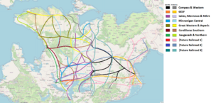
A year ago, we voted on an FSA Freight Rail plan. You can find details discussion under the discussion tab here. To summarize, a general plan comprised of existing and new large railroad companies would guide the railroad network, much like the FS Motorway scheme. Not enough people participated in the vote for it to be implemented. Speaking for myself, Mayor's sketch has been incredibly useful for planning out New Carnaby and Ruppacke. I spoke with the other coordinators, and we've decided to open the proposal up for discussion before being put up to a vote again. --Fluffr Nuttr (talk) 04:15, 6 July 2024 (UTC)
Discussion
To start, are there any thoughts on the old proposal, and if anything should be changed? I know there's interest in tying in Deodeca. --Fluffr Nuttr (talk) 04:15, 6 July 2024 (UTC)
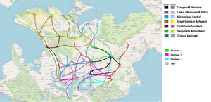
- Looking back on the previous discussion and voting results, we didn't reach a quorum and it looks like only three mappers east of the Asphale Mountains voted (Fluffr, Phrog, and ifgus), so I'm assuming if there were any concerns they were coming from the eastern stateowners. As such, I'm happy to submit a second proposal: generally speaking, everything west of the Asphale Mountains is unchanged, with three additional corridors identified (A from Huntington to the Alormen River; B from New Carnaby to Minneuka and the West Lakes; C from AR120-12 to the East Lakes). East of the Asphale Mountains, the eastern states would be able to organize their freight railroad system as they see fit, with three of the future eastern companies each being assigned to one of the three lettered corridors to cross over into the central and western FSA. This would allow the western states and Deodeca to move forward with a more solid framework while giving the eastern states more time and latitude to determine how they'd like to organize things along the eastern seaboard. (Depending on how things develop in the Northeast, an additional fourth trans-mountain corridor could be established to serve northern Michisaukee and tie into the rest of the national network at Massodeya City.) --TheMayor (talk) 17:58, 7 July 2024 (UTC)
- It isn't necessarily the case that low turnout = grievances. A plan that excludes the east, even just to give time for natural development, could give mappers in the region less of a reason to vote. I could be wrong, but I believe mappers in the east would rather refer to an existing plan than create a new one from scratch? A poll on the Eastern Forum discord could be helpful on that front. You're right though, the freight company system seems more concrete in the Lakes and West, and the eastern seaboard has more vacant states. So I won't completely rule out your proposal. --Fluffr Nuttr (talk) 03:41, 8 July 2024 (UTC)
- I'm happy to collaborate with the eastern stateowners on either modifying one of these proposals or coming up with a new idea that'd be mutually acceptable for all of us, but that'd be a more productive conversation to have here where everyone has access instead of relying on the Eastern Discord that only some mappers have access to. --TheMayor (talk) 20:14, 8 July 2024 (UTC)
- It isn't necessarily the case that low turnout = grievances. A plan that excludes the east, even just to give time for natural development, could give mappers in the region less of a reason to vote. I could be wrong, but I believe mappers in the east would rather refer to an existing plan than create a new one from scratch? A poll on the Eastern Forum discord could be helpful on that front. You're right though, the freight company system seems more concrete in the Lakes and West, and the eastern seaboard has more vacant states. So I won't completely rule out your proposal. --Fluffr Nuttr (talk) 03:41, 8 July 2024 (UTC)
- Are these corridors a basic framework or the final decision/maximum limit to railways? As a basic plan I feel this is okay but beyond that I think that regionally coordination should be allowed between ther mappers to add/extend additional rail lines and smaller branches within a company network. Brunanter (talk) 19:38, 11 July 2024 (UTC)
- The sketch is very high-level just to identify major corridors rather than specific alignments, but it is intended to also represent the general range of each company's reach. For instance, Great Western and Asperic could add additional routes and corridors throughout the West, but crossing the Alormen River or heading towards the eastern seaboard wouldn't be feasible. --TheMayor (talk) 19:48, 11 July 2024 (UTC)

