Forum:Federal States/Northeastern FSA Geography
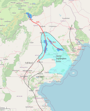
The geography of Lake Fisher has been up in the air for a while. But now, all of the states in the region have been claimed, so I was thinking we should figure this out, plus some other things. I had a bit of a preliminary discussion with Icefur2, owner of Ogdalen. From this, I think the best idea for the area would be to create a system of low-lying marshy rift valleys, one branch stretching from Lake Halison northwestwards and another along Lake Fisher and its tributaries. This sits atop a large basin centered around the Quep and Marlington watersheds, which would themselves be fairly flat. Also decided to depict a fall line, something Alessa brought up to me a while back (wasn't sure whether to follow a line through the big cities of Huntington and New Anneshire, or existing/proposed topography, so I have both here). It would be rather disrupted by the rift valley and the mountains in Laine + Eustacia, so I actually have another segment through Hazelboro.
Let me know your thoughts. Only changes needed would be a lower topography in western Laine and parts of Elway. --Fluffr Nuttr (talk) 01:54, 28 July 2023 (UTC)
