Forum:Global and regional issues/Lycene Geology
Dear Tarephians & Antarephians,
As our continents share a long and narrow interface along the Strait of Lyc, this forum entry is dedicated to building a common and somehow consistent geology for this region. Given our amateur knowledge - for the vast majority of us, I suppose - and the amount of territories still unowned or insufficiently mapped, it's highly unsure we will reach a theory that makes 100% sense. Some room should also be left for future adjustments, whether due to new owners or changes in existing countries.
Thank you for your cooperation & happy mapping. --Aiki (talk) 14:26, 12 March 2023 (UTC)
Aiki's drafts 2023-03-12: Converging Antarephia/Tarephia
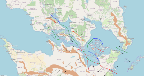
Following a short discussion outside this Wiki forum, I have tried to gather some of the elements that were presented by various mappers and combined them on a map with additional and already known natural features (e.g. mountain ranges).
Fault lines
- Mountains in Freedemia are rather high with their highest point at about 5,000m. IRL, most similar cases are either due to subduction (e.g. Andes) or continental collision (e.g Alps, Himalayas). Ruwenzori Mountains (Rift edge massif reaching 5,109m) are only 120km long. I'm not sure we can use it as an example for this region can make the sea off Freedemia a rift.
- Barzona mountains are doted with many volcanoes. Volcanoes are also present in Marize and Yusuria.
- Large mountain ranges in northern Antarephia and southern Tarephia are roughly parallel, oriented NW/SW. This may be interpreted as some kind of compression/collision.
Given these elements here's a potential interpretation:
- On the map to the right, brown is for main mountain ranges, arrows are for plate movements, blue for subduction, green for transform faults (plates are sliding, relatively to one another), red for divergent boundary and purple is for continental collision.
- Antarephia is rotating clockwise, the east is moving SW away from Tarephia while its western portion is moving NE nearer to Tarephia
- Northeastern Antarephian peninsula (where San Marcos is located) is moving away from the rest of the continent, mostly in an eastward movement, creating a fold on which the "Garonan" archipelago sits.
- The large-island archipelago in the west basin is sliding SE while being compressed by Antarephia against Tarephia.
- More to the north, Barzona is closing an oceanic remnant, causing it to dive under Barzona, creating volcanic activity in the mountain range (also due to the subduction.
- The eastern and southern basins have a complex series of oceanic extension and subduction: the southern basin is extending and its eastern part dives under another extending oceanic basin, surrounding by strings of islands.
In terms of impacts:
- Blue lines and green lines are the most likely to create earthquakes, depending on the type of rocks. For the blues, they might even create tsunamis as one plate suddenly slides under the other, lowering the water column.
- Depending on the angle, blues lines may create explosive volcanoes.
- Red lines may create a graben with horst (valley with steep edges) with or without volcanic activity. They may also correspond to a oceanic ridge with each edge moving away. --Aiki (talk) 15:30, 12 March 2023 (UTC)
- Interesting--I really appreciate the work you put into these diagrams! At the same time, I must say that this wasn't really how I envisioned the geography of my territories--the scheme puts them all on seismically active regions. It's workable, but I'll have to think about what it means for my territories. Right now, earthquakes are common in Tigeria and Kotel, but not in Inxigne or Meilan. Chazeltine (talk) 18:42, 12 March 2023 (UTC)
- This works pretty much perfectly for Freedemia and its topology as a whole, though I too didn't originally process the fact that earthquakes would be so prevalent in the area. It'll be an interesting process to figure out bigger picture and what it means for Freedemia (seems possible that our National Service Guard might be mobilized to help with earthquake damage in the region often). But as a whole it does seem like this does a pretty good job of explaining almost everything people have mapped, which is quite the feat in itself! --Ernestpkirby (talk) 04:27, 13 March 2023 (UTC)
- Thanks Ernestpkirby. After having read your comment, I did another draft, this time with Antarephia and Tarephia moving away from each other. I add a few elements for Freedemia (not sure it fits your country), such as a plateau north of the mountains to mimic the Ethiopian Highlands: the plateau is rising to the south, its edge is your mountain range that steeply falls into the coastal plain, forming a horst to this opening rift. --Aiki (talk) 22:43, 13 March 2023 (UTC)
- This works pretty much perfectly for Freedemia and its topology as a whole, though I too didn't originally process the fact that earthquakes would be so prevalent in the area. It'll be an interesting process to figure out bigger picture and what it means for Freedemia (seems possible that our National Service Guard might be mobilized to help with earthquake damage in the region often). But as a whole it does seem like this does a pretty good job of explaining almost everything people have mapped, which is quite the feat in itself! --Ernestpkirby (talk) 04:27, 13 March 2023 (UTC)
Plates
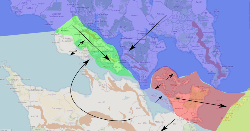
Given the elements exposed in the previous section, the map to the right displays potential tectonic plates for the Lycene region and their general direction:
- The Antarephian Plate (light grey) is rotating clockwise, vaguely around the Strait of Lyc (in its narrow sense). South of the strait, it's moving away from Tarephia while north of it, it's colliding against it.
- The unnamed green plate is moving SE with a light clockwise rotation. Its NE edge is swallowing the rest of an ancient ocean while its SE portion is being compressed by Antarephia against Tarephia.
- Two smaller plates are displayed:
- The smallest (purple) is extending away from Antarephia while being quickly subdued by the red plate.
- The red plate has two main feature: the general eastward movement and its extension in its western section.
- The Tarephian Plate is depicted in blue.
- The Asperic Plate depicted in yellow may be replaced by the Tarephian or Antarephian plate in that region, the plates' limits being moved further east. --Aiki (talk) 15:30, 12 March 2023 (UTC)
Aiki's drafts 2023-03-13: Diverging Antarephia/Tarephia
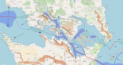
Following a short discussion outside this Wiki forum, I have tried to gather some of the elements that were presented by various mappers and combined them on a map with additional and already known natural features (e.g. mountain ranges).
Fault lines
- Mountains in Freedemia are rather high with their highest point at about 5,000m. IRL, most similar cases are either due to subduction (e.g. Andes) or continental collision (e.g Alps, Himalayas). One other possibility is to draw inspiration from the Ethiopian Highlands and Rift Valley by making these mountains sit on a high plateau that extends northward, and their south slopes fall steep into the coastal plain.
- Barzona mountains are doted with many volcanoes. Volcanoes are also present in Marize and Yusuria.
- Long mountain ranges in northern Antarephia and southern Tarephia are roughly parallel, oriented NW/SW. This may be interpreted as some kind of rift.
Given these elements here's a potential interpretation:
- On the map to the right, brown is for main mountain ranges, black lines with parallel strips are for horst, light brown is for plateaus, fountain-like icon is for the general direction of rivers, arrows are for plate movements, blue line are for subduction, blue area are for oceanic extension, green for transform faults (plates are sliding, relatively to one another), red for divergent boundary, purple is for continental collision and black-dotted lines are for undefined boundaries.
- Antarephia and Tarephia plates are in the process of separation. A long rift with branches is running from the sea off Barzona to the South Lycene Basin. The rift itself is not continuous. Around the Strait of Lyc, in the strict sense, the plates are not properly dedifferentiated. This may have formed a land bridge (or one of the land bridges) between Tarephia and Antarephia a few ten of thousands years ago. The same goes of Frankelyn and the large island: the sea there is rather shallow.
- The Budrian Plateau is an ancient landform that predates the opening of the rift. The main NW/SE rift split in two, a small part in Antarephia and a large one on the Budrian Peninsula. The opening of the rift made these parts tilt outward. The rift edge was raised while the outer edge is more or less (up to the local owners) slowly lowering.
- Northeastern Antarephian peninsula (where San Marcos is located) Plate is moving away from the rest of the continent, mostly in an eastward movement, tearing the easternmost tip of the Budrian Plateau (part of the AN100s Archipelago), and creating a fold on which the "Garonan" archipelago sits (in this version, due to the subduction of the Asperic Plate).
- Antarephia is moving SW away from Tarephia.
- The large-island archipelago the west basin and the large Tarephian Peninsula to its west are sliding W away from Tarephia.
The eastern and southern basins have a complex series of transform faults, oceanic extension and subduction: the southern basin is extending and its eastern part dives under the Northeastern Antarephian peninsula Plate. In terms of impacts:
- Blue lines and green lines are the most likely to create earthquakes, depending on the type of rocks. For the blues, they might even create tsunamis as one plate suddenly slides under the other, lowering the water column. Other lines (red/purple) may create earthquakes as well but weaker and less frequently (from what I understood).
- Depending on the angle, blues lines may create explosive volcanoes.
- Red lines may create a graben with horst (valley with steep edges) with or without volcanic activity. They may also correspond to a oceanic ridge with each edge moving away. Most volcanoes in this case are more likely to have effusive eruptions. Shield volcanoes are just one of the options. --Aiki (talk) 22:43, 13 March 2023 (UTC)
- A little harder to wrap my head around this one but this seems to work too, and would seemingly make the area slightly less prone to severe earthquakes than the other option. Per Freedemia that highland fits well overall I think, may look closer at the examples and see if I have thoughts to add. --Ernestpkirby (talk) 11:01, 14 March 2023 (UTC)
- Basically, Antarephia, more or less with Aeragny and the Barzona/Broceliande peninsula, are moving away from Tarephia (and vice-versa) in a W/SW direction. Tarephia is moving north and San Marcos peninsula, with AN100s islands is moving east. The main separation would be this diagonal NW/SE read line that runs by Freedemian west coast. Again, this is not an expert talking, I vaguely understand that severe earthquakes would be less frequent (I checked for Ethiopia and Eritrea). For the Highlands, one of the links I indicated provides topographic profiles of Ethiopia. The first one on this figure could be an inspiration for your territory: SW being understood as N and NE as S, the right tip of the plateau (under -pian of Ethiopian) would be where your main mountains range sits and roughly the Afar of the Afar Depression would be the location of the coast (e.g. Quentinsburgh). In addition, here's some Wiki articles with diagrams that may help: Rift, Great Rift Valley.
- The proposal, I think, would still "work" without the subduction off west Marize or the small purple plate. AN105-115 arc could be a graben or just a random crust fold. That would again "reduce" the number/severity of earthquake in such an enclosed body of water. --Aiki (talk) 20:53, 15 March 2023 (UTC)
- Hello, thank you for your drafts Aiki ! I think I will add a volcano on Arténie (Arténie Mainland) to be more coherent with the geology here. I've planned previously for the highest points to be at 300m above sea level, but after seeing your drafts, is it okay if I define at about 600-700 m above sea level the highest point of Arténie Mainland ? Sweetykid (talk) 09:45, 17 March 2023 (UTC)
- This looks very sensible to me, many thanks for making it! If I assume correctly, would this mean that central Teo, around the river valley in the south of the country, would end up with earthquakes? Would the geology of the area be affected in any other way? --Lithium-Ion (talk) 20:19, 18 March 2023 (UTC)
- Thanks Lithium. As I'm not an expert and we're talking fictional geography/geology of incompletely mapped regions, it's rather hard to answer properly. From what I understood, divergent boundaries have less frequent and less severe earthquakes (I did a brief search for Ethiopia, Iceland and the Azores. For the transform fault that would run across the Magellan Confederation and reaches your western border, I can't really say. It would depend on the nature of the rocks, the sub-type(s) of fault(s) or the slip rate at which the plates are moving relatively to each other. --Aiki (talk) 16:10, 19 March 2023 (UTC)
Plates
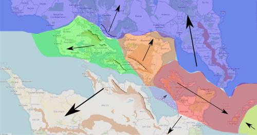
Given the elements exposed in the previous section, the map to the right displays potential tectonic plates for the Lycene region and their general direction:
- The Antarephian Plate (light grey) is moving SW, away from Tarephia landmass.
- The unnamed green plate is moving W/SW, generally following the Antarephian Plate.
- Three smaller plates are displayed:
- The smallest (purple) is extending away from Antarephia while being quickly subdued by the red plate.
- The red plate is moving in a E/SE direction, subduing the yellow Asperic Plate.
- The orange plate is almost fully attached to the Tarephian Plate and moves with it.
- The Tarephian Plate is depicted in blue and moves in general northward movement.
- The Asperic Plate depicted in yellow may be replaced by the Tarephian or Antarephian plate in that region, the plates' limits being moved further east. --Aiki (talk) 22:43, 13 March 2023 (UTC)
- As the owner of Allendea I can only approve this plan, I think it makes sense and looks great! According to this plan, which would be the most tectonically active areas? I would suggest naming the green plate the Tulyan Plate (after the Tulyan Peninsula) or the Oridican Plate (after the historic territory on the eastern half of the peninsula). --xioma_sg talk 13:09, 18 December 2023 (UTC)


