Forum:Ingrea/Geology, hydrology, and topography
The elements of geology, hydrology, and topography will be the most important part for starting up the project. A well planned geography of a nation opens doors to a lot of things in the later stages of the project. Send in your suggestions, preferably using pictures and discuss!
There are certain aspects of the national geography that are already set in place:
|
User proposals
Yuanls' proposal
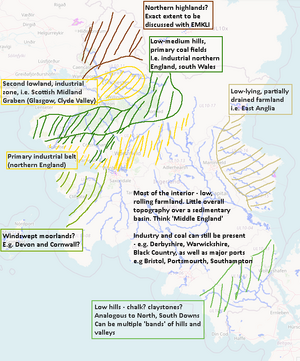
In light of the above discussions, and established geographical context (from neighbouring countries and the existing hydrology), I've produced a rudimentary geomorphological/geological/geographical map of Ingerland. I've designed it to provide a realistic, comprehensive and balanced interpretation of what Ingerland could look like. Please let me know your thoughts on this draft, and what could be added/eliminated if necessary. Yuanls (talk) 12:00, 3 May 2023 (UTC)
|
Fluffr's proposal
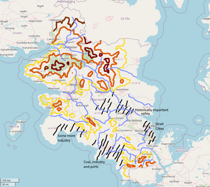
| I'm unsure to what degree I'll be participating in the collaborative areas, but I figure I'd make a plan just for discussion's sake. This shares a lot in common with Yuanls' sketch, but the areas of population are a little different. There's three big clusters of cities: an area around the capital, the strait cities (i feel like this would have been an important trade area historically disputed by Kalm), and a southern industrial belt to power the empire. I'm imagining Winburgh and Worthfield would be moved south. There's a southern chain of sporadic hills and a big clunky mountain range in the north. |
Discussion
There should be at least a low mountain range running from north to south of the country, maybe on the more western side. It kinda shows a ridge pattern that follows the islands and western side of Nordurland, and this mountain range might have affected the climate of the country like a rainshadow effect in real-world England. Senju (talk) 09:45, 29 April 2023 (UTC)
- I'm not quite sure what you're referring to? More generally, it might be worth making a sketch of highlands and lowlands. Yuanls (talk) 22:47, 29 April 2023 (UTC)
- I think the implication is either that the previous owner had a spine of glacial mountains, or something like the Pennines (which really aren't that rugged) would be desired here. I'm not taking a position on that either way, but it will need to be decided by the collective of mappers in Ingerland if there is anything notable and across regional borders. — Alessa (talk) 23:28, 29 April 2023 (UTC)
- You could always keep parts of the old north/south chain but they're more like sporadic hills, with gaps allowing for coast-to-coast corridors.--Fluffr Nuttr (talk) 00:06, 30 April 2023 (
- I think the implication is either that the previous owner had a spine of glacial mountains, or something like the Pennines (which really aren't that rugged) would be desired here. I'm not taking a position on that either way, but it will need to be decided by the collective of mappers in Ingerland if there is anything notable and across regional borders. — Alessa (talk) 23:28, 29 April 2023 (UTC)
Just a note: from what was there before Andy left, the common border between all parts of his territories and Norðurland was completely mountainous. I have not mapped many details, but everything I did map so far took this into account. --EMKLI (talk) 20:11, 29 April 2023 (UTC)
In general the geology of Britain doesn't seem too important: outside coastal areas, geology is mostly expressed though low hills in much of England (outside the north, where there's more geological variation). The expression Ingerish geology has on the landscape could therefore be left to the discretion of individual users. In terms of what's important, I propose we should pin down positions of coal fields (analogous to South Wales, the Black Country, the Pennines), and other industrial resources (e.g. metal mining in Cornwall). These resources heavily influence the industrial heritage of a region and thus human settlement, especially during and after the Industrial Revolution. On the upside, some large settlements are already mapped, and so we have a basis for where important resources may already be (assuming they won't be moved). Yuanls (talk) 22:47, 29 April 2023 (UTC)
- I agree with this fully. This was the important of why geology was even brought up. The resources will dictate things. That said, I would not rely too much on where settlements are presently mapped to pin things down. Everything left behind, including Winburgh, is up for relocation or removal just as much as staying. I would note that in the east-central regions, those relics from the past could as easily be wiped or relocated as anything else. They're a bit overbuilt and nonsensical in isolation, but we didn't want to wipe everything when there were some interesting things to potentially repurpose. — Alessa (talk) 23:28, 29 April 2023 (UTC)
Position: Ingerland is somewhat more northerly than the real UK (the southermost point of Ingerland is roughly the same latitude where Manchester, and the northernmost point is equivalent to the Faroes). This would impact the climate, and the overall shapes and features in the landscape, especially if we consider glaciations and postglacial landscapes (assuming the extent and timing of glaciations are roughly the same as they are in real life). This brings me on to one major issue I have about Ingerland: the coastline. The texture of coastline is very homogenous at the moment and does not reflect the diversity in geology and geomorphology that would be present in an area the size of Ingerland. Yuanls (talk) 22:47, 29 April 2023 (UTC)
- There is a bit of suspending disbelief that we will have to do regarding the climate, but that's only because this location is the best we can do. However, you are correct that the coastline will necessarily need work. That will be up to the regions at the guidance of the collaborative to make sense of it. The lowland marshes in the southeast should be kept to provide someone the ability to work with a terrain not unlike the Fens and other North Sea-inspired regions. — Alessa (talk) 23:28, 29 April 2023 (UTC)
Re: Fluffr and my proposals above: I don't think the geographies are incompatible (which is the main focus of this section). The main difference lies in the positions of the industrial centres and settlements (which are also slightly more detailed in Fluffr's proposal than mine). I'd double down on my geology proposal mainly the (including northern industrial belt), because firstly, it provides some better analogues to the real-world environments in the UK, and secondly, because mining coal at sea level is rather more difficult because of the water pumping issue - though having multiple centres of coal and industry would circumvent this. I prefer her updated hydrology though over the river system currently mapped. Yuanls (talk) 09:07, 9 May 2023 (UTC)
- I agree both geography proposals are large compatible, though there are aspects I prefer from both. I prefer Fluffr's terrain, and think Yuanls' terrain is a little too flat. The Northern highlands should be much more expansive and the middle England section should have parts which are mountainous to similar levels as the Peak District (up to 600m or so). However, I'm not the biggest fan of Fluffr's urban distribution, and would prefer majority of urban areas and natural resources to be inland, much like irl England (and most other European countries, such as Italy, France, Germany, etc...) I particularly am not a big fan of the straight cities idea, and don't really understand why there would be significant trade there. I like Yuanls' idea of the Northern Industrial Belt, though because of the climate of Ingerland and how far north it is, I think the main industrial belt should be south of the capital. The Northern Industrial Belt can be a secondary industrial belt, similar in size to the Scottish Midland + Tyneside combined. Gubble (talk) 12:46, 20 May 2023 (UTC)

