Forum:Territory application/AN137k
- Please fill in the information below to make a territory request.
| Territory ID and proposed name | |
|---|---|
| The Territory ID (from OpenGeofiction:Territories, e.g. AR123a) and proposed name of the country |
AN137k > Gresònhaz (Gresònhen Conlang Antarephian) / Gresonie (french) / Gresonia (international)
| Physical geography | |
|---|---|
| An overview of climate, topography and landscape of the country. It is advised to also create a sketch, you can add a link to this (hosted on imgur or similar) |
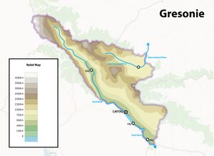
Gresònhaz (AN137k) is a predominantly mountainous territory. Much of the territory's topography and relief lines have already been mapped; they will naturally be preserved and detailed further. A large river, Vetil, flows through it, originating from the mountains. Additionally, another major international river, the name of which is yet to be determined, flows northward.
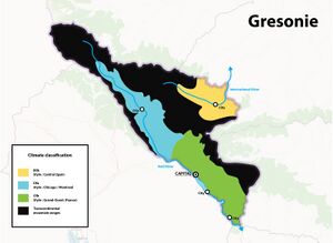
The climate is also outlined in the wiki on this page It will be predominantly mountainous, semi-arid in the north, and transition from continental to temperate towards the South.
 | Human geography |
|---|---|
| A brief description of the territory demographics, economic development, land occupation, infrastructure and mapping style |
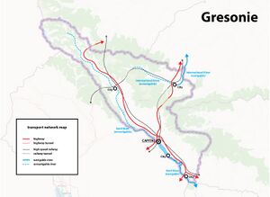
The territory is a crossroads between the north, south, as well as east and west of the continent. It is an important crossing point to traverse the continental mountain range. The population is mainly distributed in the Vetil Valley and surrounding plains. The Vetil River is navigable up to the capital; coordinating this river consistently with my southern neighbor to the ocean is essential.
The challenge for this territory will be to reconcile the passage of major communication routes, among the most important on the continent, with its rugged and magnificent nature.
| History & culture | |
|---|---|
| A brief description of the intended culture and language |
The population is primarily mountain-dwelling, predominantly French-speaking, with a culture closely aligned with Alpine peoples. Currently, Gresònhaz's history remains vague, but I believe it would be beneficial to develop it concurrently with that of my future neighbors.
EDIT : After several advice from other users the official language will be "Gresònhen" (Antarephian conlang) a language originating from the upper Vetil valley which has spread throughout the territory of Gresònhaz. We can imagine when the territory contiguous to Gresònhaz will be allocated whether the language will also be used in part or entirely or not. Other regional dialects persist in certain mountain valleys but also in the South where the Joriskjo language is spoken.
| Past mapping | |
|---|---|
| To support your request provide links to areas of OGF mapping which showcase your mapping skill. Mapping relevant to the requested theme & geography is especially useful | |
| The {{coord}} template can optionally be used to link to the OGF map - it results in a nice formatted link. Or you can paste in a URL. |
I have mapped Lorredion, a territory originally located in zone AR015, now relocated here. Concurrently, I am currently developing Bahengo, a tropical archipelago, which I intend to develop in parallel with this one. Being originally from the French Alps, it is very important to me to create a territory completely focused on the mountains and to manage the associated challenges between preserving and developing these fragile yet strategic areas.
Rivador in Lorredion (now in Franqueterre)
Bahengo currently in development
| Username & date | |
|---|---|
| Sign and date the application by typing four tildes like this: ~~~~ |
Le Mathou (talk) 15:46, 28 June 2024 (UTC)
 | Discussion |
|---|---|
| Discussion for clarification & decision |
- Hello from your southern (indirect) neighbour; I map in Kwelede-peir. Two questions / concerns: 1. As of now, Central Antarephia has no history of French colonization. Being a landlocked French post-colonial state means that the colony had the sea access sometime ago. Jorisko, which is closest country from you to the sea, was not colonized as far as I remember. 2. I am afraid countries like AN137k would have trouble constructing and maintaining big infrastructure projects, like HSR (especially in the mountainous conditions). There was an informal consensus between those who map in the area that North-Central Antarephia may have a cluster of countries with weak and unstable governments, called "the strip of instability". Lack of access to the sea and too few arable land does not fit well with French Alps style you are trying to achieve here. Would you please tell us more about your intentions for this territory? Sudo91 (talk) 03:49, 29 June 2024 (UTC)
- Hello Sudo, Regarding "the strip of instability," I haven't seen or found any information on that. If you have any info or links, I would appreciate it. Looking at the already mapped area around this territory or the wiki, it didn't seem very problematic to insert a country in this region similar to Switzerland or Austria (possibly at a different level of development; I can adapt) because the area is still very empty (especially in the northeast to the west of AN137k). For the French language, it's mainly a matter of ease and accuracy because I'm French and I like finding place names that can have an interesting historical and geographical meaning. However, if integration poses a problem, I am willing to modify it to a more international language like English. But once again, since the surrounding region is almost empty, we could imagine a cluster of French language in the region, which could bring a different culture here. Best regards. Le Mathou (talk) 07:43, 29 June 2024 (UTC)
- We could also imagine a local language, "Antarephien" for example, which would be a local language but resemble French (with many variations) in real life. I think this could be interesting as well. Le Mathou (talk) 08:08, 29 June 2024 (UTC)
- Hi!! I am Varnel maiser, the mapper of Joriskjo. My country shares a (very short) border with the proposed Gresonie. I am excited to coordinate and work on the large-scale plans for the region with you. At this time, I second Sudo's questions about how Franquese arrived in Gresonie and how we can integrate your plans into the aforementioned informal consensus (and vice versa).
The vision for Joriskjo is currently being replaced with a more detailed and organized plan, so I am happy to work with you toward creating a natural transition between it and the proposed Gresonie. --- Thanks, Zekiel (talk) 04:59, 29 June 2024 (UTC)- Hello Varnel Meiser, Personally, I'm more of a cartographer than a wiki writer. I'm simply looking to integrate elements into my map that can be coherent with the neighboring maps. I didn't think the language would be an issue because the territories to the west and north are quite empty, and we could imagine languages resembling French in these areas. I am also very eager to work together to connect our two countries, and I am curious to learn more about your development plan. I was thinking of creating a region in the south influenced by your culture, with bilingual or mixed city names. By the way, what is the language of your country? I must admit I didn't recognize it. Best regards. Le Mathou (talk) 08:01, 29 June 2024 (UTC)
- Hi again! I can send you my proposal for Joriskjo and Gresonie once I get time (in a few days). Regarding the French language, I can imagine that settlers arrived along the western or northern coasts, possibly along a similar situation as in the Lycene region (creating Broceliande). I like the idea of a dual-culture region that is a transition area between the two countries. To answer your question, Joriskjo uses a conlang called Sjepar, whose dictionary you can access by that link. I am not so much of a wiki-person myself, and I enjoy good mapping like your work. To be clear: I am supportive of this application, especially once we work out a solution for Sudo91's concerns about the proposed Strip of Instability and the origin of French in the region. --- Thanks, Zekiel (talk) 17:37, 2 July 2024 (UTC)
- Hi Zekiel, No problem about your plan, take your time. I’m also working on improving and detailing mine. Regarding the language, as I mentioned earlier, I think I will also use a local conlang "Gresònhen" (Antarephian conlang), which could be interesting. This wouldn't prevent us from having a region with a dual culture at the border of our countries. About the instability zone, I must admit I didn't fully understand and couldn't find any information about it. Thanks for your support! So far, I haven't heard back from the admins. Best regards.Le Mathou (talk) 09:56, 3 July 2024 (UTC)
- Hi Le Mathou! I put something together very quickly for reference, which you can access at this link. I will remove the "danger zone/military zone" currently forming the border between Joriskjo and the proposed Gresònhen to allow direct highway and railway connections. While I am not sure about a high-speed railway link all the way to the border, I support a "higher" speed (160 km/h to 180 km/h) express rail line between Sjonafari and the southernmost city of Gresònhen, to connect to the rest of the Joriskjo-Reàskuskjo HSR.
Regarding the Strip of Instability, I was able to find a screenshot of the proposal, which you can access at this link. The idea is that during the 20th (and into today) century, many of these territories had unstable governments that threatened the stability of the region. I imagined that Joriskjo would (covertly) act in the region to safeguard its interests (usually to stabilize its neighbours). For example, AnimationSky (Reàskuskjo) and I discussed Jorisken intervention in Reàskuskjo politics to induce regime change there, leading to its stabilization in the 1990s. There was some discussion about it primarily between the surrounding territory owners, but I will defer to Sudo91 for more details since I cannot find much about it on the wiki. I think that Gresònhen can be changed to "former" instead of "current," with a date of stablization around the 1970s or 1980s. --- Thanks, Zekiel (talk) 14:20, 3 July 2024 (UTC)- Great, this map seems like a really interesting idea. We'll have to see how we can implement this bicultural region, but it seems like a cool concept to develop. As for the train, no problem, the express line works for me, and we can consider adding a high-speed line in the future, which will add an RP element to our mapping. Thanks for the map of the so-called Strip of Instability, and yes, it seems like a good solution to change it from current to former for me as well. Thanks for everything!
- Hi Le Mathou! I put something together very quickly for reference, which you can access at this link. I will remove the "danger zone/military zone" currently forming the border between Joriskjo and the proposed Gresònhen to allow direct highway and railway connections. While I am not sure about a high-speed railway link all the way to the border, I support a "higher" speed (160 km/h to 180 km/h) express rail line between Sjonafari and the southernmost city of Gresònhen, to connect to the rest of the Joriskjo-Reàskuskjo HSR.
- Hi Zekiel, No problem about your plan, take your time. I’m also working on improving and detailing mine. Regarding the language, as I mentioned earlier, I think I will also use a local conlang "Gresònhen" (Antarephian conlang), which could be interesting. This wouldn't prevent us from having a region with a dual culture at the border of our countries. About the instability zone, I must admit I didn't fully understand and couldn't find any information about it. Thanks for your support! So far, I haven't heard back from the admins. Best regards.Le Mathou (talk) 09:56, 3 July 2024 (UTC)
- Hi again! I can send you my proposal for Joriskjo and Gresonie once I get time (in a few days). Regarding the French language, I can imagine that settlers arrived along the western or northern coasts, possibly along a similar situation as in the Lycene region (creating Broceliande). I like the idea of a dual-culture region that is a transition area between the two countries. To answer your question, Joriskjo uses a conlang called Sjepar, whose dictionary you can access by that link. I am not so much of a wiki-person myself, and I enjoy good mapping like your work. To be clear: I am supportive of this application, especially once we work out a solution for Sudo91's concerns about the proposed Strip of Instability and the origin of French in the region. --- Thanks, Zekiel (talk) 17:37, 2 July 2024 (UTC)
- Hello Varnel Meiser, Personally, I'm more of a cartographer than a wiki writer. I'm simply looking to integrate elements into my map that can be coherent with the neighboring maps. I didn't think the language would be an issue because the territories to the west and north are quite empty, and we could imagine languages resembling French in these areas. I am also very eager to work together to connect our two countries, and I am curious to learn more about your development plan. I was thinking of creating a region in the south influenced by your culture, with bilingual or mixed city names. By the way, what is the language of your country? I must admit I didn't recognize it. Best regards. Le Mathou (talk) 08:01, 29 June 2024 (UTC)
- Hi, this is an exciting application for the region! When the region was redesigned and cut down into smaller territories after the Bythorium Empire (I may misspell its name) left, the Western Alps served indeed as the main inspiration (roughly same orientation, same latitude and same location from a western continental coast), with the Swiss Plateau lakes (Neuchâtel, Constance) and the main chain some 50-ish km in the background, and with the northern tip of the territory acting as some kind of Valais (AN137k is actually slightly larger than Switzerland). AN137k may be an important North-South/East/West transit corridor for Antarephia with its large valleys, mountain passes and probably tunnels later in history. I imagine, like in the French Alps and Switzerland in the 19th century/early 20th, these mountain rivers were endowed with hydropower dams enabling such things as industrialisation or railway electrification to cross those mountains. Or, the complete opposite, the topography isolates regions with all it entails. The only "issue" I see would be the language as Antarephia, outside its northern coast, has been more or less dedicated to territories having no real correspondence in the real world (+ as pointed out by other, AN137k is landlocked and located pretty inland). If you opt for a colang, you may always based it on another/others Antarephian colangs or fully invent your own. For Guaiian, I started with a few odonyms and built the vocabulary/proper nouns over the year. Some toponyms are full-blown calques from existing places, especially in France (e.g. in Guai, there is an Aiguille Verte), others are just random real-world language phrases that have been applied Guaiian spelling (e.g. the village Tatakart is t'as ta carte? to which I later explained by tata- being a pre-Taukan prefix meaning fortified village enabling multiple derivations). For the rest (culture/history/economy), continents' guidelines are designed to be loose enough to accommodate various mapping projects, especially in largely unmapped regions. Bonne chance pour ta demande! --Aiki (talk) 16:21, 29 June 2024 (UTC)
- Hello Le Mathou. I am very impressed with your application. Your plans provided and the maps for the plan look very well thought out, you are an experienced mapper with lots of quality mapping, and like mentioned above, there is a lot of leeway in the guidelines for your application plans to fit well into this region. Language and the location/history would also have been my only concern, but as this has already been addressed and there is already good collaboration and discussions with surrounding mappers, and everything that has been said and discussed above, I have very little to add to the discussion except for that I will approve your application. Happy mapping and exited to see what you create! —PortCal (talk) 21:51, 4 July 2024 (UTC)
 |
Territory application approved |
|---|---|
| Approved by comment above. Good luck mapping! —PortCal (talk) 21:51, 4 July 2024 (UTC) | |
| As you develop your territory, be sure to keep it realistic. Here are some resources you may find useful for starting out: Help:Portal, Help:Making realistic countries, Help:Making realistic cities and OpenGeofiction:Site policies |


