Forum:Territory application/AN334 - Sterrenkust
- Please fill in the information below to make a territory request.
| Territory ID and proposed name | |
|---|---|
| The Territory ID (from OpenGeofiction:Territories, e.g. AR123a) and proposed name of the country |
| Physical geography | |
|---|---|
| An overview of climate, topography and landscape of the country. It is advised to also create a sketch, you can add a link to this (hosted on imgur or similar) |
The country consists of three islands (as at present) of volcanic origin. There are two clearly visible volcanic cones on the main island, each approximately 400-500 meters high. The coastline is characterized by rocky cliffs (with natural rock pools in some areas) and volcanic beaches, with an extensive lagoon on the eastern side. Various coral reefs surround the island. The vegetation mainly consists of orchards (nutmeg trees) and untouched rainforest on the steeper slopes.
 | Human geography |
|---|---|
| A brief description of the territory demographics, economic development, land occupation, infrastructure and mapping style |
Sterrenkust is home to over 100,000 inhabitants, the majority of whom live in the capital on the southern side of the main island. Additionally, there are around ten small and medium-sized settlements scattered along the coast. Most residents are descendants of Lentian colonists or migrants from neighboring countries. The country has a very high HDI and a relatively high GDP per capita, with banking, ecotourism, and agriculture (nutmeg cultivation) as its main industries. The island features an airport with a single runway in the southeast, as well as multiple ports and ferry connections. A coastal road encircles almost the entire main island, complemented by a newer parallel route that, through the use of modern bridges and tunnels, connects the various settlements far more efficiently.
| History & culture | |
|---|---|
| A brief description of the intended culture and language |
Although the archipelago was already inhabited around the beginning of the Common Era, it was found abandoned upon its rediscovery by Lentian explorers in the early 17th century. A colony was established, initially focusing on nutmeg production, but over the course of the 19th century, it increasingly gained popularity as a winter retreat for the wealthy elite from the motherland. A grand city was designed in colonial style, featuring theaters, parks, and promenades, while spa resorts were built in the mountains. This led to the development of a vibrant cultural and nightlife scene, and even in the early decades of the 20th century, the island retained its appeal to the elite. However, the archipelago then fell into relative isolation due to economic crises, leading to stagnation in both trade and tourism. But when the colony successfully declared independence in the 1970s, it strategically reinvented itself as a financial hub, attracting foreign investment through favorable tax regulations. This economic shift, combined with a revival of its cultural heritage—restoring historic districts, promoting the arts, and developing high-end tourism—reestablished the islands as a prestigious destination for the upper class of the former motherland.
| Past mapping | |
|---|---|
| To support your request provide links to areas of OGF mapping which showcase your mapping skill. Mapping relevant to the requested theme & geography is especially useful | |
| The {{coord}} template can optionally be used to link to the OGF map - it results in a nice formatted link. Or you can paste in a URL. |
https://opengeofiction.net/edit#map=16/-13.5853/152.8066
| Username & date | |
|---|---|
| Sign and date the application by typing four tildes like this: ~~~~ |
Jannesvs (talk) 19:51, 15 February 2025 (UTC)
 | Discussion |
|---|---|
| Discussion for clarification & decision |
Hi Jannesvs,
Thank you for your application. I have some questions regarding it:
- Physical geography
- Could you please provide a draft map of your project? I'm a bit confused the 3 islands you mentioned for AN334∈⊾ as I could count 6 larger islands. Which one is supposed to be the "Main Island"?
- I'm not a botanist, but after a quick check, it seems nutmeg trees grow closer to the equator (apparently ~0-10°). AN334 is located ~30-32°S.
- Human geography
- Same as for physical geography, a draft map might help understand the project.
- History & culture
- 17th century, might be a bit late for this part of the world. According to some of the greater region countries' page, they were colonised or came in contact with Ulethan a few centuries earlier. I'm not sure it could have been "rediscovered" then as other islands of this small and not-so-isolated archipelago seemed to have been colonised by Castellan and Valony as well. Maybe Lentia took it from another colonial power then or was it colonised way earlier? You may reach Lentia's coordinator to check for consistency?
- The rest sounds reasonably consistent, though I'm unsure a set of islands would have been christened "Sterrenkust". I feel -kust (like former Gold Coast, Ivory Coast or Pepper Coast) fits better sections of a continental coastal area than a 11,000km2 archipelago.
- Past mapping
- Thank you for the link: very reminiscent of the Dutch countryside.
--Aiki (talk) 06:53, 17 February 2025 (UTC)
Hi Aiki!
Thank you very much for your detailed feedback! I'll try to respond as clearly as possible below.
Physical Geography
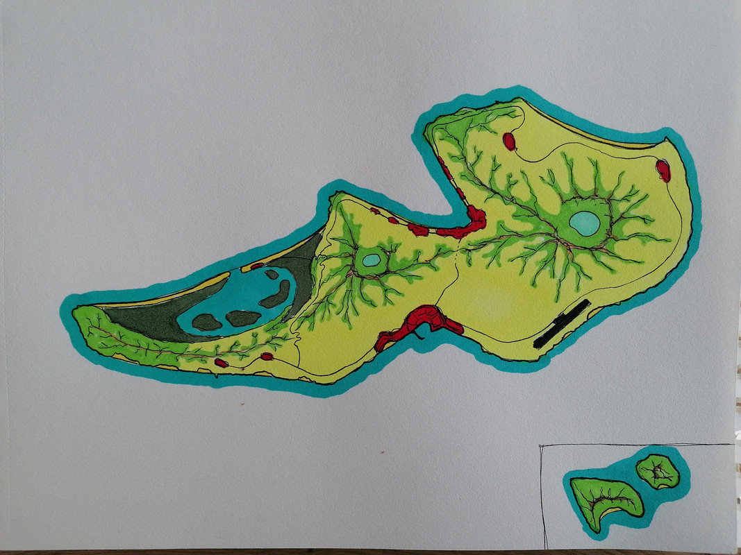
- Here is a map (https://i.postimg.cc/vTxpcBg2/IMG-20250216-162016.jpg) of my idea for Sterrenkust. I now understand where the confusion arose: I hadn't realized that AN334 was much larger than just Ggeleo, the far eastern part of the archipelago. For my idea, I was looking for a small, relatively isolated island or island group in the tropics, and this seemed like the perfect match. Would it be possible to claim a part of AN334?
- Nutmeg is originally from the Banda Islands and parts of the Moluccas, which have an Af climate bordering an Aw climate. Nowadays, it is also cultivated in Aw-climate regions (parts of Brazil, Grenada in the Caribbean, and southern Florida). Since the northeast of AN334 has an Aw climate and likely still receives significant winter rainfall on the windward side of the proposed volcanoes (north coast), my idea was to center nutmeg plantations there. The local microclimate should likely be suitable for this kind of agriculture.
- The southern side would have a slightly drier character, with a more tree-savanna-like landscape on the steep slopes instead of rainforest, and a cultural landscape on the flatter areas—perhaps suited for more Mediterranean-style agriculture or extensive livestock farming.
History and Culture
- The early 17th century fits well into the timeline of Lentia’s colonial expansion (the founding of two colonial companies in 1604). Since it concerns the outermost part of the archipelago, I imagined that the islands might have been overlooked until then (as the prevailing winds blow away from them) or deliberately ignored due to their small size and lack of cultivation. Or perhaps intense volcanic activity in previous centuries had driven away earlier inhabitants? I see several plausible scenarios here.
- Interesting that you bring up naming conventions—I’ve also thought a lot about this. I know that colonial names like the Gold Coast, Slave Coast, Pepper Coast, and Ivory Coast mainly referred to coastal regions as “gateways” to resource-rich hinterlands, which is not the case here. At the same time, the term “coast” was also used administratively by the WIC in what was then the West Indies (e.g., “Java's Northeast Coast” and “Sumatra's West Coast”).
- Dutch colonial names were often based on older indigenous names (not applicable here), the name of encountered resources (not directly relevant, as plantations developed only after colonization), places or people from the motherland (a possible option), or “romantic” names like “Cape of Good Hope”, “Vredeburg (Peace Castle)” or “Zwaanendael” (Swan Valley). I’d like to imagine that after weeks of heavy, overcast weather (this oceanic region experiences many hurricanes), explorers finally saw a clear, starry sky to navigate by—shortly before spotting a coastline on the horizon.
Jannesvs (talk) 19:42, 18 February 2025 (UTC)
- Hi Jannesvs, thank you for the draft, it does makes things clearer. It is possible to claim part of AN334 (e.g. those 3 islands only).
Please bear in mind that the new territory would quite small (183km2 incl. 177km2 from the main island) with the main island roughly the size of Texel but way more isolated, the next island to the SW is ~100km away. Comparing it to real-world example, that should guide your considerations for the territory's history, development, population....
Having said that, would you be still requesting this sized-down territory or would you like consider others instead?
--Aiki (talk) 00:57, 19 February 2025 (UTC)
Hi Aiki,
Thank you for the clarification. I understand the constraints and isolation of the territory. I would still like to proceed with claiming the mentioned part of AN334 (the three islands, approximately 183 km² in total).
I will take these factors into account as much as possible when developing the territory’s history, population, and infrastructure. I see this as an exciting challenge to create a unique project, and I appreciate that the limited scale allows me to focus on quality rather than quantity.
Please let me know if there are any further steps I need to take.
Best regards, Jannesvs (talk) 14:06, 19 February 2025 (UTC)
- Hi, sized-down AN334 is yours. Here's some information that may find useful:
 |
Territory application approved |
|---|---|
| --Aiki (talk) 22:48, 19 February 2025 (UTC) | |
| As you develop your territory, be sure to keep it realistic. Here are some resources you may find useful for starting out: Help:Portal, Help:Making realistic countries, Help:Making realistic cities and OpenGeofiction:Site policies |