Forum:Territory application/UL1098+UL1098 - Tairnas Brethia
- Please fill in the information below to make a territory request.
| Territory ID and proposed name | |
|---|---|
| The Territory ID (from OpenGeofiction:Territories, e.g. AR123a) and proposed name of the country |
UL10-98 & UL10-99 - Tairnas Brethia
| Physical geography | |
|---|---|
| An overview of climate, topography and landscape of the country. It is advised to also create a sketch, you can add a link to this (hosted on imgur or similar) |
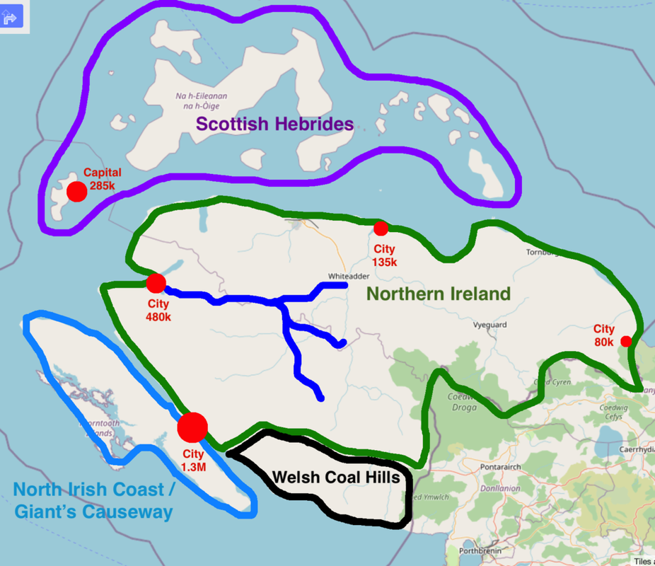
Reference sketch located here
Broadly speaking the territory would be based off of parts of Britain outside of England. North Ireland would be the core geological reference, with relatively low rolling, mostly agricultural and forested terrain with some larger hills (mirroring the apparent topography of neighboring Tircambry) with a healthy smattering of bogs and smaller lakes. The jagged peninsula to the southwest would be modeled on the northern coast of Ireland, specifically the area around Giant's Causeway, to take advantage of the work already done on the coastline. To the east of that peninsula's junction with the mainland would be a hilly area based on the coal mining hills surrounding Cardiff in South Wales. The islands to the north would be inspired by the Hebrides in Scotland and the Aran Islands off the west coast of Ireland. The Baltics (especially Estonia) would also be used as a geographical reference point due to similarities in climate (though would not serve as a cultural influence).
 | Human geography |
|---|---|
| A brief description of the territory demographics, economic development, land occupation, infrastructure and mapping style |
Urbanization would be almost entirely concentrated along the coastline, where the Ingerish developed cities to export natural resources to the homeland across the Vinn Sea. Pre-colonization, the main city would have been a trading hub with a historic center loosely based on the cities of the Hanseatic League. Population would be more concentrated in the west and south, closer to Ingerland, as the territory's industrial economy developed in the late 17th century as the Ingerish developed an extremely productive network of coal mines in the hills along the southern coast. While much of the northern islands would be rural and rocky, the westernmost island is home to the capital city, moved here by the Ingerish in the late 19th century to allow the ruling Ingerish political class some distance from the turmoil caused by nationalists on the mainland. The peninsula's central hills would be largely agricultural, and the rugged northern coast would be loosely modeled off of Ireland's western "empty coast" with a seacoast highway in the vein of the Wild Atlantic Way, dotted with fishing villages now largely given over to tourism.
The five largest metropolitan areas would be Caronica (1.3 million, loosely based on Cardiff), the commercial and cultural hub of the peninsula since pre-colonial times thanks to its prominence in the Vinn Sea trade as a center for the production of vibrantly dyed and woven woolen fabrics; Glanaravon (480K, loosely based on Hull), a secondary port and historic cultural center heavily influenced by the Ingerish after it was rebuilt following a devastating fire in the mid-17th century; Vinnhaven (285K, loosely based on Blackpool), the pirate hideout-turned seaside resort-turned-Ingerish territorial capital; Tyreshore (135K, loosely based on Lincoln), an ancient Caletic spiritual center with a colonial economy long centered on production of a Brethian whiskey known as wisecrag; and Gascott / Csycod (80K, loosely based on Galway), a socialist hotspot and hub of Caeltic culture, home to a university focused on the preservation of the peninsula's native language.
| History & culture | |
|---|---|
| A brief description of the intended culture and language |
Tairnas Brethia is the area of the Brethian Peninsula conquered by the invading Ingerish in the 12th/13th centuries CE. The territory has a rich pre-colonial history as part of the larger Caeltic cultural area, and its landscape is dotted with ancient henges, Bronze Age ring forts, and other markers of this legacy. Many place names, while mostly Ingricized, have Caeltic (Welsh) roots, and in some areas (especially in the more nationalistic north) locals have reverted to using Caeltic place names. While the Ingerish have ruled the area for many centuries, nationalist movements have waxed and waned over time but never completely dissipated. This first led to the removal of the territorial capital from Caronica to Vinnhaven in the 1850s and the renaming of the area from Ingrean Brethia to Tairnas Brethia (from the Caeltic word teyrnas, or realm) to suggest a certain amount of autonomy in the 1860s. A century later, it led to the Bifurcation in 1960, which split the territory into two distinct areas: the south/west, along with Vinnhaven island (UL10-99), and the north/east (UL10-98). This was done to stymie the political power of the more nationalistic north, and led to over a quarter-century of political violence known in the Ingerish speaking world as the Brethian Mire. The AN managed to broker a lasting peace in 1986, and while the area remains part of Ingrea, more allowances have been made in recent decades for Caeltic cultural and religious traditions, leading to a resurgence of the practice of Dwiniaid, an ancient pagan faith now practiced by more than 8% of the population.
| Past mapping | |
|---|---|
| To support your request provide links to areas of OGF mapping which showcase your mapping skill. Mapping relevant to the requested theme & geography is especially useful | |
| The {{coord}} template can optionally be used to link to the OGF map - it results in a nice formatted link. Or you can paste in a URL. |
My earliest OGF work was in the territory now known as South Serion, including the forest cover in the north and the karst hills along the eastern coastline. I later created Ayir Ahali Al-Kaza where the most detailed mapping exists in the capital city of Canan-Yar and an unnamed agricultural region. Finally, I created the city of Seniqe while working as part of the original team collaboratively mapping Dematísna.
| Username & date | |
|---|---|
| Sign and date the application by typing four tildes like this: ~~~~ |
Louis walker (talk) 18:14, 11 February 2025 (UTC)
 | Discussion |
|---|---|
| Discussion for clarification & decision |
- Hi, Louis. Welcome back! A couple quick notes, and then we can wrap this up.
- Just to confirm: is the territory going to be mapped mostly in "Ingerish" with a few notable placenames in the northeastern half? I want to ensure that it is still a heavily 'Ingerish'/'Ingrean' territory for the sake of canonical history. Given the likely gradient of naming usage, I suggest naming the two regions as Ingrean Brethia (west, -99) and Tairnas Brethia (east, -99). Both can have a regional hub for governmental and economic institutions. I believe maintaining it as two separate regions is useful here: the west like Cornwall, where the vestiges of the old culture are very, very faint; the east more like Northern Ireland, where it's status is more complicated but still very much in the Ingrean realm. Does that make sense?
- Thank you for your patience for me to get back to this. If all is good here, I'll approve it promptly. Cheers! — Alessa (talk) 13:53, 18 February 2025 (UTC)
- Hi Alessa! Yes, that's exactly right, I'll be mapping in English, with certain place names in the northeast including both English and Welsh versions (i.e. Derry/Londonderry in rw Northern Ireland on OSM). I'm generally cool with what you're suggesting, with the two territories formally separating into separate provinces in the 1980s after being bifurcated but still under the control of Vinnhaven in 1960. If that sounds good, I'll start figuring out how the heck to get JOSM to start working on my laptop again, lol. — Louis walker (talk) 18:39, 18 February 2025 (UTC)
 |
Territory application approved |
|---|---|
| — Alessa (talk) 21:15, 18 February 2025 (UTC) | |
| Please keep in mind that these regions are part of Ingrea, a pretty centralised country. Keep in mind that major decisions about regional structure and other meta factors of history are defined by the collective of mappers in all of Ingrea. |