Forum:Territory application/UL15f - Csanádország
| Territory ID and proposed name | |
|---|---|
| The Territory ID (from OpenGeofiction:Territories, e.g. AR123a) and proposed name of the country |
UL15f - Csanádország
Csanádország would be a closed collaborative territorry, the coordinators would be: oo_raiser, tule00, poissott and sergjack.
A sort of "continuation" of Escadia, rebranded as the homeland to the Csanádok, the Hungarians of OGF.
All of the existing mapping, and with it the physical and human geography will be preserved.
| Physical geography | |
|---|---|
| An overview of climate, topography and landscape of the country. It is advised to also create a sketch, you can add a link to this (hosted on imgur or similar) |
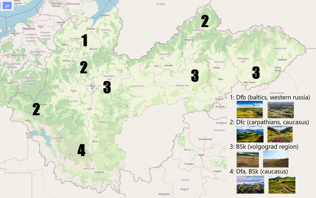
Csanádország is divided into 2 large climatological sections: the temperate north and the dry south, divided by a mountain chain with peaks about 1.5km tall. In the north, there is a temperate, albeit cold climate similar to the climate of the Baltic countries or western Russia. In the south, the climate is that of a cold, dry steppe, with very little rainfall, similar to the climate of the Volgograd region of Russia, as well as southern Ukraine and northern Kazakhstan.
 | Human geography |
|---|---|
| A brief description of the territory demographics, economic development, land occupation, infrastructure and mapping style |
Csanádország is a medium-to-high income mixed economy with a high human developement index, following a transition from a centralized planned economy in the 1980s. The region north of the mountain range is more densely populated and economically active than the region to the south of the mountains, with the south and far east being the poorest and sparsest regions.
| History & culture | |
|---|---|
| A brief description of the intended culture and language |
The Csanád people (Csanádok, OGF:Hungarians) are a Uralic people group that speak the Csanád (OGF: Hungarian) language and settled in the area thousands of years ago. In 1153, a real union was formed between the Csanád kingdom and Mallyore. This continued until 1918, when Mallyore became an independent country. Shortly afterwards, during or after the Great War, Csanádország transitioned to authoritarianism. Authoritarian rule lasted until the late 1970s, when internal and external pressures caused weakening of government power. This led to Banuvia declaring independence in 1981, and following a failed attempt to reconquer it, the political system collapsed entirely and after a brief period of instability Csanádország reformed itself as a republic. Today Csanádország is a medium-high income country with a mostly functioning democratic system, albeit with remnants of the former authoritarian system. Many former high-ranking officials and their families form a powerful oligarchy with a lot of influence in the government. It is part of the Egalian Union and maintains relations with it's former dependencies, while also being diplomatically close to Suria.
| Past mapping | |
|---|---|
| To support your request provide links to areas of OGF mapping which showcase your mapping skill. Mapping relevant to the requested theme & geography is especially useful | |
| The {{coord}} template can optionally be used to link to the OGF map - it results in a nice formatted link. Or you can paste in a URL. |
Sergjack:
Poissott:
https://opengeofiction.net/#map=8/61.142/83.452&layers=5
oo_raiser had demonstrated sufficient mapping skill to be a coordinator of this collaborative project, but his mapping portfolio in the beginner teritorry was deleted entirely in the meantime.
tule00:
| Username & date | |
|---|---|
| Sign and date the application by typing four tildes like this: ~~~~ |
Sergjack (talk) 20:18, 12 March 2025 (UTC)
tule00 (call me SJ) talk · ̇OGF 10:03, 2 April 2025 (UTC)
 | Discussion |
|---|---|
| Discussion for clarification & decision |
 |
Territory application approved |
|---|---|
| Approved. Please be aware of the difference with a closed collab. The activities of the coordinators will be monitored and this territory is eligible to be withdrawn, unlike community collabs. Please create a collab info page. Request as a whole is good. ⸺ Bixelkoven (talk) (West Uletha Admin) 21:29, 2 April 2025 (UTC) | |
| Dear oo_raiser, tule00, poissott and sergjack. The territory application is good, everything fits with the lore, even the continuation of Finno-Ugric in this territory (Estonian to Hungarian) from the previous works of eklas are a great touch. I would have to comment how all of you that possess territories (three of you), still have a long way before completing your current territories, though all of you are very proficient mappers and the mapping quality is excellent. Notably, User:Poissott has already joined a collaborative project nearby recently. Because of that, I advise all of you to stick to the projects you are involved in, including UL15f, without requesting further expansions. This is a collab, and I am on a see-saw of thoughts whether more collabs are good or bad, there's plenty already. I am also aware of the mapping by User:OO_Raiser that has been deleted, I vividly remember how it looked like. Lastly, the already present skeleton for the country, as well as the landcover gives you the upper hand with this project, use it wisely. Happy mapping! |

