Forum:Territory application/UL25f - Tekurius
- Please fill in the information below to make a territory request.
Preface.
Back in October 2023, I requested a small territory in Axian peninsula named Rémnokkälja, but I over-estimated my possibilities in making a conlang which source was a poorly researched language (namely, Tocharian A). Also, the country was heavily depended on an external context (it was a centre of pilgrimage for an obscure syncretic religion with an unknown amount of followers) and that served more as an restriction for me rather than an attempt to create a coherent international lore.
| Territory ID and proposed name | |
|---|---|
| The Territory ID (from OpenGeofiction:Territories, e.g. AR123a) and proposed name of the country |
UL25f -- Tekurius /tɛ.'ku.ri.ʊs/. Either as an additional territory or as an exchange for Rémnokkälja.
| Physical geography | |
|---|---|
| An overview of climate, topography and landscape of the country. It is advised to also create a sketch, you can add a link to this (hosted on imgur or similar) |
Tekurius has a temperate monsoon climate with mean temperatures in January and July being -5 / +20 Celsius, and observing 1 000 mm of precipitation annually.
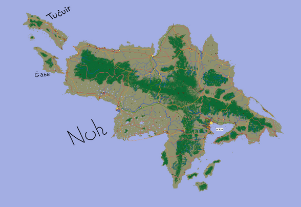
Tekurius is an insular state that lies on three main islands -- Nuch, Tuċuir and Ġabö. Two mountain ranges cross Nuch in a form of a plus sign, with highest mountain being 614 m above sea.
Karst lakes are widespread on the western side of Nuh. Four big lagoons are also present.
Here is the draft map for Tekurius that shows approximate forest covers, main rivers, new coastline, main mountains, settlements, roads (green/orange/pink) and railways (red).
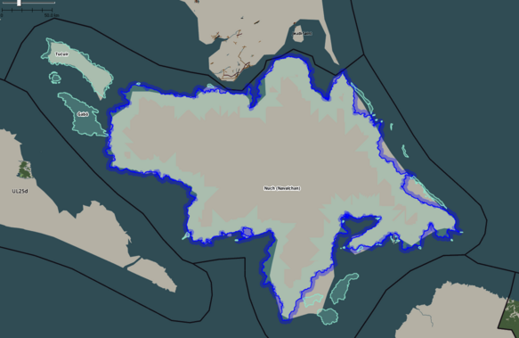
This picture shows the new suggested outline, compared to the current one.
 | Human geography |
|---|---|
| A brief description of the territory demographics, economic development, land occupation, infrastructure and mapping style |
Demography
The population was at 984 000 in 2024 and it decreased by 11 000 in the past decade. Around 60-70% of population live in urban or semi-urban areas that cover roughly 2% of the country.
The economy is export-oriented, with unprocessed natural resources and seafood being the most profitable export products.
GDP per capita was 6 000 $ (nominal) / 16 000$ (PPP).
The land is dominant with podzols and brown soils, making the volume of agricultural production per hectare quite low and large areas are being allocated for plowing. Cereals are grown, and rice is also present in the river valleys. Cattle are raised only for milk; almost no meat is produced domestically.
Tekurian roads are poorly maintained due to low rates of car ownership (<150 per 1000 people) and prevalence of railway transport. Public transport, albeit not being widespread, is used frequently by citizens
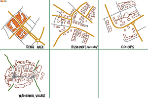
Downtown areas of Tekurian cities have colonial-style planning with dense areas and grid street layout.
Suburban area have irregular street layout and are way less dense than downtown areas. They may include rowhouses and detached houses alike.
Below-mentioned "Co-ops" are essentially microdistricts with a flavour of constructivist architecture.
Traditional Tekurian settlements are dense, jam-packed iron-age "fortress villages" with barns and industrial facilities being located on the edge of the village, forming a wall that protects residences in the middle.
| History & culture | |
|---|---|
| A brief description of the intended culture and language |
History
Tekurius was a colony of Franqueterre from mid-18th century until early 1940s. Before that, a small iron-age tribal kingdom was present on the islands.
During Great War, an uprising by native Tekurians was started which then resulted in a full-scale partisan war against colonial government. Many Franquese fled the islands, and in 1962/63 Tekurian government was formed and Tekurius was proclaimed as "Doonist (as explained by user Ūdilugbulgidħū on one of his obsolete OGF Wiki pages) entity" on a referendum in May 1963.
Language
This time I already have a more or less developed conlang which should keep me from abandoning this territory (I hope). The conlang is an isolate with vague possible connections to Uralic languages, Nivkh and Ainu.
| Past mapping | |
|---|---|
| To support your request provide links to areas of OGF mapping which showcase your mapping skill. Mapping relevant to the requested theme & geography is especially useful | |
| The {{coord}} template can optionally be used to link to the OGF map - it results in a nice formatted link. Or you can paste in a URL. |
Recent (complete large scale mapping) includes Mordvin' in Suria: https://opengeofiction.net/#map=15/43.2356/93.1302&layers=B
| Username & date | |
|---|---|
| Sign and date the application by typing four tildes like this: ~~~~ |
Sudo91 (talk) 19:08, 3 June 2024 (UTC)
 | Discussion |
|---|---|
| Discussion for clarification & decision |
Dear sudo, thank you very much for your well planned territory application. Regarding Rémnokkälja: since Rémnokkälja is not the only territory you own (and you said yourself that you are not particularly interested in mapping it much further), you would have to indeed exchange Rémnokkälja if you are going for a new personal territory such as UL25f. I would however leave the mapping in Rémnokkälja in place when making it available to new territory applications. This would mean it will most likely effectively stay the same for the forseeable future, since the sector is quite inactive. Only when a new mapper interested in this territory comes around, we would then have to revisit the question of whether they would want to keep the existing mapping or have it wiped, and in the latter case you could then decide if you want to save some of it.
Regarding the application for UL25f: the human and natural geography is exceptionally well done for the sake of a territory application, so no further questions regarding that. Just two things where I was wondering if you could elaborate:
You speak of a "temperate monsoon climate". Going by the climate consensus, the climate would probably be similar to St John's, which is humid continental according to wikipedia. Now I'm not a climate expert, but when I look at this wikipedia entry, temperate monsoon seems to be much warmer and drier than what I would expect for this island. The temperatures and precipitation that you describe however very much match that of St John's. So I wonder if there's just some confusion about the term "temperate monsoon climate" between the two of us?
Secondly, I want to point out that going by the East Uletha Concept, the linguistic themes of the sector are intended to be "Germanic/Northern European, Celtic, Conlangs". Justinique is more of an exception to this theme. If you want to stick to a French colonial theme, you are welcome to do so, especially since much of the mapping (judging by the draft map) seems to be planned in the native conlang anyways; but if the colonial langauge is something you are still sitting on the fence about, you could also consider Germanic or Northern European linguistic influences, which would make a little more sense looking at the neighbouring sectors. Just some food for thought - curious to hear what your plans are.
Looking forward to hearing from you, all the best, Leowezy (talk) 13:53, 4 June 2024 (UTC)
Hello Leowezy, thank you for your feedback.
Regarding "temperate monsoon climate"... I believe this is indeed a misunderstandment. This term is not used in Köppen climate classification, rather in Boris Alisov climate classification that I used to study at school. This map shows such areas under indexes 23 and 24: Vladivostok, Beijing, Hokkaido, Quebec and Canadian Atlantic Provinces (incl. St. John's) are among the places that are located in that area.
Regarding the second question, I chose Franquese because of the proximity to Justinique, but knowing that Ulethan Scythe is in process of rework, I may consider other possibilities for colonial background.
Sudo91 (talk) 18:53, 4 June 2024 (UTC)
 |
Territory application approved |
|---|---|
| Approved, in exchange for Rémnokkälja. | |
| As you develop your territory, be sure to keep it realistic. Here are some resources you may find useful for starting out: Help:Portal, Help:Making realistic countries, Help:Making realistic cities and OpenGeofiction:Site policies |


