Forum:Territory application/UL26f - Aizaqāraśaḅūmī (ऐषगारशबूमी)
Note: ¹ - Sanskrit should be given its own name on OGF.
| Territory ID and proposed name | |
|---|---|
| The Territory ID (from OpenGeofiction:Territories, e.g. AR123a) and proposed name of the country |
UL26f - Aizaqāraśaḅūmī (ऐषगारशभूमी)
| Physical geography | |
|---|---|
| An overview of climate, topography and landscape of the country. It is advised to also create a sketch, you can add a link to this (hosted on imgur or similar) |
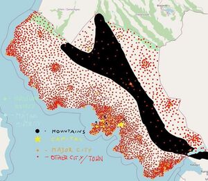
Aizaqāraśaḅūmī is between moderate and meditterean country. It's a some kind of merge between Southern Europe, Middle East and India.
(also i would like to suggest lenghtening Carpathian Mountains so they'll diagonally cut through the territory)
 | Human geography |
|---|---|
| A brief description of the territory demographics, economic development, land occupation, infrastructure and mapping style |
Economically, Aizaqāraśaḅūmī is on average really wealthy, yet there is still some disproportion between coastal regions and north of the country with the coast being the richest.
Ethnically the country is overally homogenous, of course with exception of borderous areas.
Mapping style is indirectly mentioned above (check the sentence about similarities to the real world)
| History & culture | |
|---|---|
| A brief description of the intended culture and language |
Aizaqāraśaḅūmī people, similarly to Jambukhand people, came form unknown West Ulethan territories, most propably from terrains of modern day Cástellan. One thing we know is that these two nations lost contact at the turn of the eras. At the same time, Sanskrit¹ of Aizaqāraśaḅūmī started evolving differently as the Sanskrit¹ of Jambukhand, soon to form a different language. Aizaqāraśaḅūmī nation most propably stopped migrating in IIIrd century. Even though they ended up not far away from Jambukhand, they still maintained their version of Sanskrit¹. At first they weren't moving away from coasts at all, thus only in Xth century they started attempting to cross the mountain range. They ended up establishing their occupation behind the mountain range in XIVth or XVth century (historicians are not sure). Aizaqāraśaḅūmī lived peacefully and warless with other countries, having only one war in its history. (that was when [insert here colonialism-liking country] tried to colonize the nation in 1650s)
| Past mapping | |
|---|---|
| To support your request provide links to areas of OGF mapping which showcase your mapping skill. Mapping relevant to the requested theme & geography is especially useful | |
| The {{coord}} template can optionally be used to link to the OGF map - it results in a nice formatted link. Or you can paste in a URL. |
Urban area: https://opengeofiction.net/#map=15/12.2665/-111.8150&layers=B
I wasn't mapping here for very long. After 3 weeks i moved out to Rhododactylia, in which i'm still editing. Yet you can see my mapping being high quality, even it there isn't much of it here.
Rural area: https://opengeofiction.net/#map=15/-8.9967/169.4385&layers=B
I mapped this quite recently. KNLA has many ghost towns (towns having basically nothing except the label). Thus i decided to map one of them. I did it in the course of three days.
Transportation:
https://wiki.opengeofiction.net/util/route_relations.html?map=C/14/-10.45093/166.91837 (Surfside City), https://wiki.opengeofiction.net/util/route_relations.html?map=C/14/-3.96410/168.11949 (Gyvetown)
This is the part i definetely like the most. In Surfside City i added tram lines (there are 8 of them) and some stops to a network done by someone else, someone that is sadly not active (at least i think so)
Meanwhile in Gyvetown I added line relation to already existing tracks and added a second branch to Werleyside.
Macromapping: https://opengeofiction.net/#map=10/-9.0461/169.4463&layers=B
The things you should notice are adjusted to mountains border and new or rerouted roads.
I also highly recommend you to compare everything to OSM Carto (05 testing) layer.
PS. The mapping doesn't quite match the style i'll be using, yet I think i'll be able to match the style of the region.
| Username & date | |
|---|---|
| Sign and date the application by typing four tildes like this: ~~~~ |
SleepyAks (talk) 20:09, 18 February 2024 (UTC)
 | Discussion |
|---|---|
| Discussion for clarification & decision |
Dear SleepyAks, thank you for your application. It fits in very well with the sector UL26 and your mapping in the beginner territories qualify you for a private territory. Before proceeding with (finally) approving your application and handing over the territory, please prepare a macro plan for the natural and human geography of your country and provide a rough sketch. This sketch is not binding for the future development but is meant to stimulate your mapping as you start off. See Help:Making_realistic_countries for some tips on how to make such a plan, sketching the most important mountain ranges, rivers, cities and transport links. A rough sketch with microsoft paint or some other basic tool of your choice is absolutely fine. Looking forward to your reply, all the best, Leowezy (talk) 19:16, 19 February 2024 (UTC)
SleepyAks (talk) 23:01, 19 February 2024 (UTC)
- Note: Discord CDN links only last for 24 hours. Hotlinking to Discord's CDN is not a good idea. I have uploaded the image on SleepyAks' behalf. Lemuria (talk) 23:12, 19 February 2024 (UTC)
 |
Territory application approved |
|---|---|
| Approved, Leowezy (talk) 16:43, 20 February 2024 (UTC) | |
| As you develop your territory, be sure to keep it realistic. Here are some resources you may find useful for starting out: Help:Portal, Help:Making realistic countries, Help:Making realistic cities and OpenGeofiction:Site policies |
