Maka

|
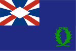
Republic of Maka akarar Maka (Makaan) Capital: Tafue
Population: 16,832 (2018) Motto: « Den ghaadaro co kete den Maka ahkaa » Anthem: « Anthem of Maka / Maksaadghaso » |
Loading map... |
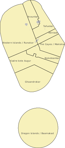
Maka, officially the Republic of Maka is a small island state in the northern Asperic Ocean. Located in the Iscuan Chain of islands between Iscu and Ste. Marie and Ste. Helene, Maka is located at the edge of the Plurinesian Sea. It is graced with a tropical climate and favorable trade winds, along with a wealth of biodiversity and native culture. The government of the island is a unicameral federal republic, but due to the small size and economy of the territory it relies on Gobrassanya to handle foreign relations, trade, defence, and a large percentage of government funding. Thus, Maka is generally considered an associated state of Gobrassanya. It is not a member of the AN, being represented by Gobrassanya, but takes part independently in relevant AN sub-organizations as well as some other multi-national agreements. The economy depends mainly on tourism and fishing. There has been a recent drive to fully convert to green energy.
Maka was a loose confederation of chieftains when the Ingerish arrived in 1527. The Ingerish quickly imposed colonial government on the natives, who were not able to resist. Maka was quickly absorbed into the Ingerish dominion as a small trading outpost, and the natives suffered from mistreatment. However, very little permanent Ingerish settlement actually occurred, and in 1913 Maka was cut loose from the Ingerish Empire, but was annexed by Iscu instead of gaining independence. Maka separated itself from Iscu in 1955 and established the governmental structure of today, but was forced to depend on Gobrassanya for financial aid, setting up the dependent relationship that continues today. The nation avoided the troubles that plagued Iscu in the 80s, and so has retained a more favorable reputation. The islanders have been able to reclaim their cultural heritage and many practice their traditional religion. The Makaan language is the majority language. Along with their neighbors, the islands have recently seen a bloom in foreign investment and settlers, which has spurred the construction of numerous new resorts and eco-tourism ventures to take advantage of the unique volcanic geography of the islands.
Etymology
History
Prehistory
Early Chiefdoms (200 BCE - 800 AD)
Ghandraa Period (800 - 1200)
First Confederation (1290 - 1380)
Second Confederation (1420 - 1527)
Ingerish Territory (1527 - 1712)
Ingerish Dominion (1712 - 1913)
Iscuan Control (1913 - 1955)
Modern Republic (1955- )
Geography
Climate
Environment and Wildlife
Municipalities
Abinaav / Damned Isle
Population: 0
Largest Settlements: N/A
Araunkar
Population:
Largest Settlements: Araun, Aman
Dragon Islands / Baamakad
Population:
Largest Settlements:
Nokeleankar
Population: 4590
Largest Settlements: Paasoa, Lannref
Composed of the island Nokelean and a small number of low-lying islands to the north, Nokeleankar is the most populated municipality outside of Tafue. Like Endeburg in Iscu, Lannref, the largest village and municipal seat, was founded by Lentians as part of their trading network, but was never officially a Lentian colony or possession. Paasoa, the oldest village on the island, dates back to the pre-contact period and retains much of the original building styles of the period, including a remarkable town hall.[1] The island was developed substantially by a few Ingerish agricultural interests in the 1800s, and most of the original forests were cut down in favor of large industrial orchards, which are now mainly operated by Enluna Inc, a multi-national firm operating out of Khaiwoon, whose practices on Nokelean have been criticized by locals as exploitative.[2]
Despite the widespread deforestation, a remarkable amount of diversity remains in the natural environment. Some of the only mangrove habitat in Maka remains on Nokelean, but is in danger from the fish farms that have replaced most of its original coverage area. In addition, on the southern coast lie the Koleanalenna Dunes, which are protected as a nature reserve and see some of the highest visitation rates in the southern cayes by migratory birds, making it a little-known haven for bird-watchers. [3]
The Cayes / Makiokar
Population: 713
Largest Settlements: Pagrao, Guahako
The Cayes were part of Nokeleankar until 1997, when the Second Municipal Reorganization Act was passed. The Cayes, however, have always been distinct from the rest of the southern islands by virtue of their low population, extremely flat land and grassy beaches. Mediator Island is the most unique of the cayes, being, in effect, an extremely long sandbar with two slightly more elevated ends, covered with thick, low-hanging vegetation and multiple small pools of fresh (albeit brackish) water. The two "twin cayes", Pago and Egua, are connected by a shallow section of the same reef that connects them to Mediator. They are both similar to Mediator in vegetation, but Pago is mainly just forest and beach, in comparison to the grassier Egua. The reef ford between the two cayes is now a popular spot for viral photos taken by the tourists that make it all the way out there.
Thanks to the relative and climatic remoteness of the Cayes, especially when contrasted to the availability of Nokelean, they have seen little settlement by the Ingerish or Maakans, with the two villages on Pago and Egua respectively, Pagrao and Guahako, dating back to at least the 1300s. Pagrao, which was connected only recently by airstrip in 1993, is primarily a fishing village and serves as the central settlement for the municipality. Guahako is slightly smaller than Pagrao, but the wetter soil of Egua, supported by two spring-fed ponds, allows for quite a bit of orchard farming, primarily of breadfruit, plantains, coconuts, and some yams. The twin cayes have seen little of historical note over the centuries, but have recently been gaining popularity as day trip destinations from Nokelean.
Because of the aforementioned lack of constant settlement in the Cayes, Mediator Island, which had been until that point uninhabited, saw its first settlement in 1955, under somewhat dubious circumstances. Edwin B. Balgor, an Apostolic preacher in Iscu, had been accumulating a following as a "new prophet" since the early 40s, and was increasingly coming under scrutiny from the government at the time, which disliked his apocalyptic preaching. He saw Maka, which was agitating for independence, as the perfect place to start a commune of his followers. At the time, new settlements were prohibited, but as the referendum for independence was occuring, approximately 300 members of what was now, in Balgor's wording "the Church of the Thankful Flock", sailed to Mediator Island to set up a new settlement. It was an unmitigated disaster. Balgor did not have the appropriate materials to set up a new village, and after an outbreak of cholera, a rare tropical storm, and a great deal of mistreatment, around half of the 200 remaining settlers left, leaving the other 100 or so to continue their new village. The Maakan government, which was displeased with the new settlement, and the settlers who left, each attempted legal action against Balgor. Both cases failed, and Balgor ultimately led the small village of St. Alfegevu for the remainder of his life, becoming increasingly controlling: at one point ordering gunfire against a group of sailors who tried to fish too close to the village. The Church of the Thankful Flock has been declared a cult by multiple humanitarian organizations. In 1993, a set of its leaders were indicted for murder and other crimes, but the Church, somewhat diminished, continues to practise in St. Alfegevu to this day.
Ghaandrokar
Population:
Largest Settlements: Ghandro-ran, Ghandro-le
Kadre kete Augur
Population: 465
Largest Settlements: Amnebo-bol, Ulanoos
The trio of islands that compose Kadre kete Augur (Ing: Kadre and Augur) have no historical relation to each other. The most distinctive island is Kadre and its volcanic peak Oomokraro, which has a sharply craggy profile. Kadre has been never been inhabited, but is occasionally visited for pilgrimages to the top of Oomokraro, which most recently erupted in 2002.[4] Its nearby neighbor, Anger Islet, was also only sporadically inhabited during the pre-contact period until the construction of the Anger Islet Air Force Base by the Federal States in 1932, and then transferred to Iscu after the end of the Great War. Augur, the small settlement on Anger Islet, sprung up to support the base. The government of Maka mothballed the base due to budgetary and other political concerns in 1962, shortly after independence. Although the decommissioning was intended to be temporary, the deterioration of the airstrip and the lack of incentive to reopen it resulted in the base being fully closed in 1990.
Before the base deteriorated significantly, it was used as the main filming location in the seminal adventure film Stranded on War Island (1968). Augur remained after the closure, and persists as a small fishing community.[5]
The northern island of Fal-ulaan was added to the municipality (being removed from Nokeleankar) in 1973 as part of the First Municipal Reorganization Act (FMRA), and local administration was transferred to it thanks to its much higher population, which is around 80% of the total population of the municipality. Fal-ulaan is a small, sandy island that is the southern part of the Nokelean group of islands, and has two pre-contact settlements: Amnebo-bol and Ulanoos. The two villages have all but merged thanks to mild population growth in the latter half of the 20th Century, but remain isolated from the rest of Maka and are rarely visited. The school for the municipality is located in Amnebo-bol.[5]
Tafuekar
Population:
Largest Settlements: Tafue
Western Islands / Runakar
Population:
Largest Settlements:
Government and Politics
Government
Tribal groups
Free association
Demographics
Ethnicity
Religion
Education
Health
Economy
Infrastructure
Culture
Language
Music
Art
Cuisine
Holidays and Festivals
References
- ↑ Nokeleankar Municipal Government (2020) Nokeleankar - overview, Available at: https://www.maka.nokeleankar.mk (Accessed: 2022).
- ↑ Fores, S.A (2014) Enluna: Island Exploiter, Available at: https://www.khaiwoonsentinel.com/plurinesia/2014/enluna-exploiter (Accessed: 2022).
- ↑ Ooma, D (2019) Natural Landscapes of Maka's Southern Islands, 3rd edn., Suvuma: Royal Suvuman Publishers.
- ↑ High Mountain Society (2023) Makaan Volcanoes: Overview, Available at: https://www.highmountainsociety.org/countries/maka (Accessed: March 20th 2023).
- ↑ 5.0 5.1 Makaan Historical Society (2022) History of Kadre ket Augur, Available at: https://www.mkhs.mk/kadre-ket-augur (Accessed: March 20th 2023).


