Bako-Huz
| Bako-Huz Federal City | |||||
|---|---|---|---|---|---|
| Capital City | |||||
| |||||
| Country | Kofuku | ||||
| • Region | Raissak∈⊾ | ||||
| • Komune | Bako-Huz Federal City∈⊾ | ||||
| |||||
| Demonym | Bakohuzian | ||||
| Government | |||||
| • Komune President | Zarttan Zahino of Sentrum | ||||
| • Komune Co-President | Bjørn Dosker of Russkbru | ||||
| Area | |||||
| • Total | 97 km2 | ||||
| • Urban | tbd km2 | ||||
| Elevation | tbd m (tbd ft) | ||||
| Population | |||||
| • Census (2021) | 1 060 360 | ||||
| • Density | 10 976/km2 | ||||
| Postal Code | 0100 to 0199 | ||||
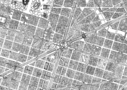
Bako-Huz the capital city of Kofuku. Located in the administrative region of Raissak∈⊾, north of Kofuku. It currently holds 1.060.360 inhabitants according to the 2021 census. Bako-Huz is the second most populated city of Kofuku after Metrocolis∈⊾. The land area of the Federal City is 96,6km2. Holding 15 districts inside.
As the city expanded, it annexed some of the surrounding towns. Making it now hold 5 historic centres (Bako-Huz centre, Andelimouth, Upgedes, Firefly, and Fynestar). This, apart from a considerable amount of monuments and historical significance, makes it the most touristic city of Kofuku and among the first in the Antarephia continent. The port of Bako-Huz provides with external trade to a big area of Harda Island. Turning this city into a centre of cargo commerce.
With the 1833 urban expansion and a dense network of railways, the city rapidly occupied the valley where it now stands. This lead to a early development of this city following Ulethan standards.
Bako-Huz is currently a sister city with San Martín and Navenna City
Etymology
Bako-Huz has had that name only since 1733. The city had the name “Gerberg” before. Bako was the name of one of the neighbourhoods, near the river. Bako is the Darrsyan word for “Square/Plaza”. Bako is a neighbourhood surrounding a big square of the city named Jagged Grove∈⊾
Huz is the oldest neighbourhood of the city. It was founded around the 1st century as a mining village between two mountains rich in iron. The word “Huz” is the Darrsyan word for Iron (Fe).
On the year 1733 Gerberg suffered the so called “Gerberg Great Fire” in which only the neighbourhoods of Bako and Huz survived the flames. As the city was no longer existent, the area would be called Bako and Huz, later Bako-Huz. When rebuilding the city this name was kept instead of restoring the old one.
Symbols and Flags
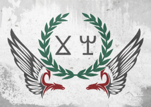
The city of Bako-Huz used this symbol/flag when it was the capital city of the Andel Kingdom. This was kept as the city symbol until the Kofuken Colonial Era. The Zahino family was provided the control of Bako-Huz by the Ingerish colonial governor. The Zahino family’s coat of arms was introduced as the city symbol under the colonial rule. That has been the city symbol and flag until nowadays.
City
Monuments
Urbanism
Parks
Administration
The administration of Bako-Huz is divided into two sections. The popular government and the administration council.
The administration council is elected every 3 years and the Komune President every 6 years. Both of them by democratic vote. At the moment, the Komune President is Zarttan Zahino of Sentrum, the Komune Co-President is Byørn Dosker of Russkbru, and the Federation Representative is Pyter Kanjar of Txot.
The popular government is made up of volunteers, residents of Bako-Huz, from all neighbourhoods of the city. The administration council shares the city management with the popular government.
The city administration can also be made by the District Popular Government. Which manages certain aspects of a specific district.
Embassies
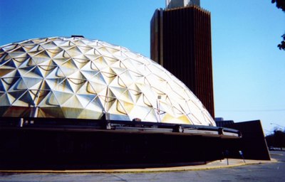
Bako-Huz being the capital city of Kofuku, holds the embassies and diplomatic relations. Embassies are all across the city, but mainly on the La Ronda neighbourhood. Between the old city and the Central Train Station. In this place there is a building called Embassies Dome that holds a big number of them.
Districts
Antykonet
Andelimouth
[File:Kupferstich - Ingolstadt - 1818.jpg|thumb|left|Andelimouth 1802]] Andelimouth is first mentioned on the year 1432 on a census list. Written as “Andelyme, ar tyl Andel jangaste yasta” meaning “Andelyme, the village at the Andel River Ending” in Darrsian. Here it is shown that before the Ingerish colonisation, it was named Andelyme. Under the Ingerish rule it was changed to Andelimouth to have a name closer to Ingrea ones
The main touristic attraction of Andelimouth is the Basilica and the Red City Walls.
The Andelimouth Red City Walls were built on the year 1602 and reinforced on the year 1682. Under Ingerish rule the walls were added a new line of protection against cannons. It was used as the Ingerish colonial headquarters. Bako-Huz was too big and old for this.
The Andelimouth Basilica construction started in 1719 and ended in 1787. It has red walls and a green (oxidised-copper) roof the front facade holds two towers that act as bell towers.
The river Andel passes through Andelimouth. From where the district gets it’s name. The river sides are 25 meters elevated over the water. The first bridge across it was built in 1496. A big stone bridge part of the road from Bako-Huz to the Andel Valley. Nowadays it is only peatonal. Two road bridges were built under it.
The Sejve Emperor Mausoleum and the Mark Yado Mausoleum are located on the Andelimouth South Gates. The founder of the Kofuken nation, and the leader of the independence against Ingrea, respectively.
Sentrum
Kazkachay
Nemesis
Nova Valença
Vertevannet
Upgedes
Fynestar
Urbanova
Orion
Firefly
Outbako
Karamelouz
Narf Nywoon
History
Zelanar Prehistoric Settlement
This settlement was discovered in 1876 by one of the forest rangers of this area. On 1893 the archaeologist Gorka Yagoson started a few minor excavations. He managed to convince the city to buy the terrain. Only 10% of the area was excavated by then. On 1956 the Bako-Huz government ordered to continue the excavations under the supervision of the archaeologist Kevin Hotz. After 9 the excavations ended and the area was open to visitors along with a small gallery where small remains are exposed. The parking lot was opened in 2004.
Gerberg
Before 1733, Bako-Huz name was “Gerberg”. Gerberg was founded around the 1st century as an iron mining village. Located on the current neighbourhood of Old Huz It continued being a village until the 1220s, when it conquered surrounding villages and created the Andel Kingdom. Slowly the village continued to grow to a big city as the centre of the Kingdom.
Under the Ingerish rule the city expanded and grew, as it was selected to be the capital of the Kofuku Colony. As explained in the Etymology section, the Great Gerberg Fire of 1733 destroyed the city.
Industrial Revolution
Modern Area
Geography
Bako-Huz is located on the end of the Andel Valley, that comes from the west. With the Bjørn Bay on the northeast. The Kalangur plains on the east. The Fyne Monts on the south and more mountains on the North. Some city districts on the north and south of the city are located in valleys between hills. The rest of the city is relatively flat.
The Andel River crosses the whole city. Lakes can also be found inside the city. For example: Vertevannet Lake, George Lake, Zelanar Lake, Titovannet Lake, Moondew Lake, and Amusvann Lake.
Pollution
Across history, Bako-Huz hasn’t been a health city. When the Industrial Revolution first arrived to the country this city turned into being the industrial centre. Nowadays Bako-Huz still preserves remains of that industrial past. Such as the big inner railway network, the Lucca industries, and the Bako Este Industries.
Air pollution: The industrial activity polluted the city’s air until 1980 when a regulation on factory smoke was passed. Around that time, most factories had already moved from the city to the countryside. The regulation nowadays doesn’t allow the few factories still remaining in the city to produce any type of air pollution.
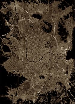
Light pollution: currently the light pollution of Bako-Huz is very high compared to the rest of the country. As it can be seen on this night picture, the mountains and lakes of the city make black shadows, while the rest of the city is alight. From the city, it is really hard to see stars, and only a few of them can be spotted. The surrounding areas also are affected from this light pollution. Currently the population doesn’t find it to be an issue.
Sound pollution: The average residential street in Bako-Huz is much less noisy than on the rest of the world. Highways constantly are provided with sound barriers to prevent noise reaching the living spaces. Currently the neighbourhood who is more sound pollution is Ohedes, which holds several stadiums and the city’s nightlife.
Public services
Garbage management
Bako-Huz only has one recycling centre and landfill on the southwest of the city. This garbage complex consists of two surface landfills, two underground landfills, and 13 buildings for recycling the garbage of the city. Next to it there’s a highway connection and several street to the rest of the city.
Water and sewage
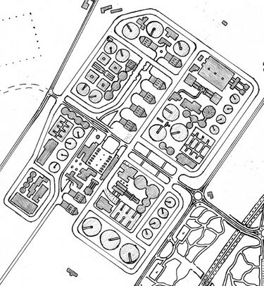
The clean water of Bako-Huz comes from the nearby valleys. Almost a 100% of the sewage passes through the Treatment Plants where it is cleaned before being thrown away. One of them being the East sewage treatment plant (the small one), and the other one the West sewage treatment plant (the big one).
Power (electricity)
most of the power that comes into the city passes through either of these electric stations. One of them being theSouth electric station and the other the East electric station.
Education
Health
Emergencies
Firefighters and Police
Post offices
Radio-TV
Culture
Museums
Holidays
1st January - New Year
6th January - Gift-giving
20th February - Carnival of Bako-Huz
2nd March - Independence Day
3rd April - Antarephia Day
1st May - Work Day
20 June - Fire Festival
27 Agust - Rayssak Day
22-23 September - Spring Festival
26 October - Bako-Huz Day
1 November - All Saints
24-25 December - Christmas’s Eve & Christmas
Sport
Transportation
Bako-Huz holds a very dense transportation network. Mainly on public transport. Being cars extremely regulated, public transport is very important for the well functioning of the city.
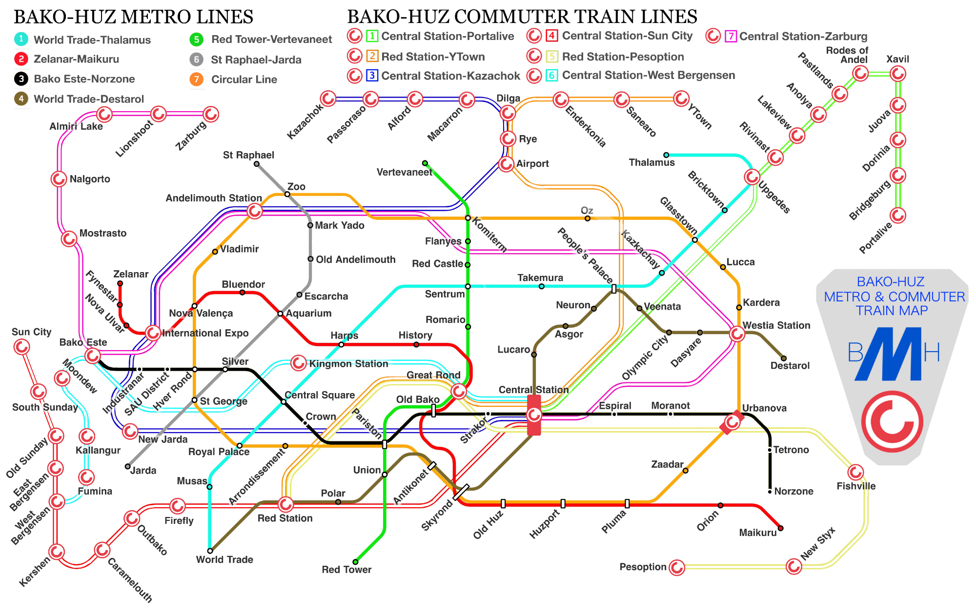
Metro and Commuter Train
Port
Bako-Huz holds one of the main Antarephian cargo ports. The surface extension is very high and provides capacity for numerous ships transporting cargo, bulk, or other goods. A computer-based coordination as well as a rail network inside the port makes it easier for goods to move across quickly.
The port is divided into 8 areas. Being the first 5 on the east side of the city and the remaining 3 on the north.
Area 1 consists mainly on passenger transport. Ferries and cruisers, but also a military port and cargo.
Area 3 is the biggest area, which holds a huge complex for gas and petroleum products. It also has a small marina on the south.
Area 4 holds a container cargo facility. With a big amount of Triple-E cranes and a railway yard.
Area 6 As well as the port, Area 6 has an industrial land.
Airport
Highways
Buses
Bicycles
The citizens of Bako-Huz feel proud of having a percentage as high as 36% of transportation being made by bicycles. This has been made possible thanks to the dense network of cycle-ways and the so called "Bicycle Highways". These are a series of bicycle-ways which are designed to not have traffic lights or intersections with regular streets. As a normal car-highway would do. This allows for a fluent non-stop flow, therefore moving though the city much quicker, even sometimes faster than by car.


