Collab:Suvuma
To discuss about the country, go to the [forum discussion thread].
This is the main page for reference on collaborative guidelines towards the territory of Suvuma∈⊾.
Loading map...
Organization
The collab would be led by Davieerr. Users that wish to participate would be asked to define their proposed work and then granted permission to edit in that area. There will be reserved areas as the map provided bellow will show; all mapping in Suvuma would be subjected to chance if needed, but with the prior notification of the original user who mapped the area. To prevent edit conflicts, users would be notified of and encouraged to be mindful of others in the area.
Participants
| User | Role |
|---|---|
| Davieerr, (wiki) | Coordinator |
| BMSOUZA, (wiki) | Contributor |
| Kyunzi, (wiki) | Contributor |
| user, (wiki) | Contributor |
Theme
Suvuma is a collab based on the prior work of the user Isleño, because of the lack of context regaurding Suvuma, there will be a definition of the cultural and liguistical backrounds of the island. It will have strong south-east asian influence, with both Dravidian/Austronesian languages present in the island. There are expected to be important historically walled cities along the northwestern coast, prevalence of austronesian and hinud religious institutions, and lots of historic sites that would be from 1000 B.P's foward. However, there would be a ancient influence of hellinisian culture steming from Telkarnatha, but that would be mostly in ethnical backround and some historical sites.
Suvuma will have a few major cities along mainly the coast, and a planned capital in its northern region of the island. Most of the southwestern coast will be highly forested. Most of the major infrastucture will be located in the northern half of the island. The capital of Suvuma is Suviliana with Pembasa and Khorys serving as major urban areas. Port Thunder and Fever Bay will be historical Ingrean colonies that will present english-speaking writing, as part of a ingrean minority still in the region.
Territorial history
- 80000 B.P to 50000 B.P First human migration wave to the region.
- 50000 B.P to 12000 B.P Pre-Historical cultures developed.
- 12000 B.P to 6000 B.P Early austronesian cultures developed in southern Suvuma.
- 6000 B.P to 2500 B.P Outward migration of austronesians.
- 2500 B.P to 1000 B.P Migration of Dravidian people, first kingdoms.
- 1000 B.P to 300 A.P First major empires in the island.
- 300 A.P to 600 B.P Telkarnathan influence over in the western shores.
- 600 A.P to 1200 A.P Rise on Dravidian Kingdoms.
- 1200 A.P to 1500 A.P Corsarian polities on eastern shore.
- 1500 A.P to 1700 A.P Rise on Goytakanyo Kingdom.
- 1700 A.P and foward Continuation of prior "established" history.
Language
Telugu Would be the dominant Dravidian Family, with Malayalam and Telugu being minorities on the northern tip of the island. The southern half will be predominant in Malayo-Polynesian and Formosan. The base map, for better user interactivity will be made in latinized form, with more important names, such as major cities, states and similar having the original language's alphabet as a alternative in the name:language category.
Old Wiki
In the text below, there is the entire written old wiki page of Suvuma.
Suvuma, officially the 'Suvumese Federal Republic' (SFR), is a large island nation situated between Uletha and Archanta. It also lays claim to the smaller nation of Goytakanya, located approximately 60 kilometers off its western shoreline.
The climate of Suvuma is tropical and much of the country is covered by lush rain forests, featuring a vast array of unique biodiversity. Despite efforts from conservationists worldwide, these forests continue to be destroyed at a rapid pace, as the expanding population spreads southward from the heavily populated north of the island. In 2003 the Assembly of Nations issued its first "Global Environmental Alert," calling for protection of Suvumese lowland and highland rain forest ecosystems.
Suvuma is also home to a wide diversity of ethnic and cultural groups, ranging from the dominant Suvu who control the military and government, to an unknown number of small and largely uncontacted groups deep in the interior. Since Suvuma's independence from Ingerland, ethnic conflict has been widespread, most notably between the Suvu and the Goytakano, a minority group that had occupied most high ranking positions during the colonial era.
After independence the Goytakano were violently forced out of power, and many fled offshore to Goytakanya. Goytakano guerrilla forces repelled Suvuma's initial invasion attempt, but the Suvumese regime still claims Goytakanya as an integral part of its territory, and even includes the island on the map featured in its coat of arms. The tension between Suvuma and Goytakanya is a major point of potential conflict in the world today, with Suvuma's government regularly threatening.
GDP per capita =$5,910
HDI=0.52
Territorial layout
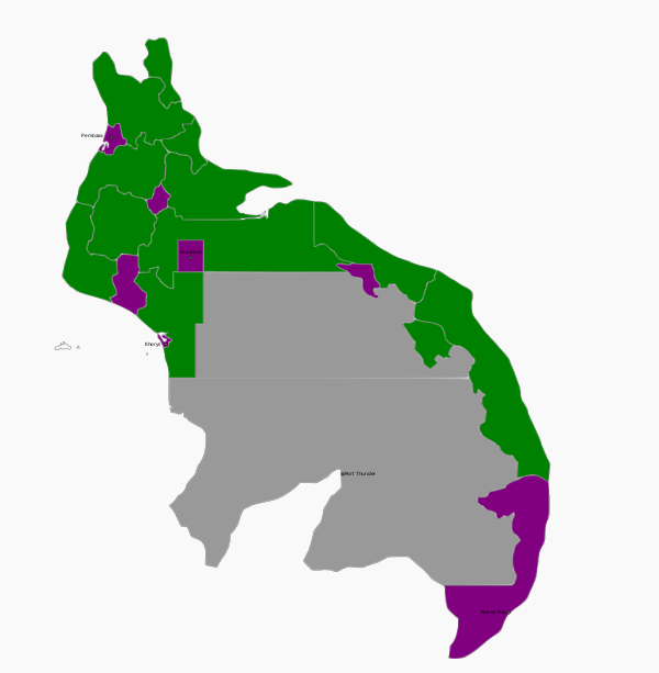
The majority of the population will be located in the northern half of the island and eastern shore. Below, follows the division of territories, with the few named cities already put in place and the avalability being put into place as well: Collab (Purple); Open to Claim: (Green); Reserved (Grey);

Territories
| Ref | Name | Capital | Type | Contributor | Notes |
|---|---|---|---|---|---|
| UL33e-01 | -- | Available |
| ||
| UL33e-02 | -- | Available |
| ||
| UL33e-03 | -- | Pembasa | Collaborative |
| |
| UL33e-04 | -- | Available |
| ||
| UL33e-05 | -- | Available |
| ||
| UL33e-06 | -- | Available |
| ||
| UL33e-07 | -- | Collaborative | |||
| UL33e-08 | -- | Available |
| ||
| UL33e-09 | -- | Available |
| ||
| UL33e-10 | -- | Collaborative |
| ||
| UL33e-11 | -- | Available | |||
| UL33e-12 | Suviliana | Suviliana | Collaborative |
| |
| UL33e-13 | -- | Available |
| ||
| UL33e-14 | Khorys | Khorys | Collaborative |
| |
| UL33e-15 | -- | Reserved | |||
| UL33e-16 | -- | Available |
| ||
| UL33e-17 | -- | Available |
| ||
| UL33e-18 | -- | Available |
| ||
| UL33e-19 | -- | Port Thunder | Reserved |
| |
| UL33e-20 | -- | Fever Bay | Available |
|
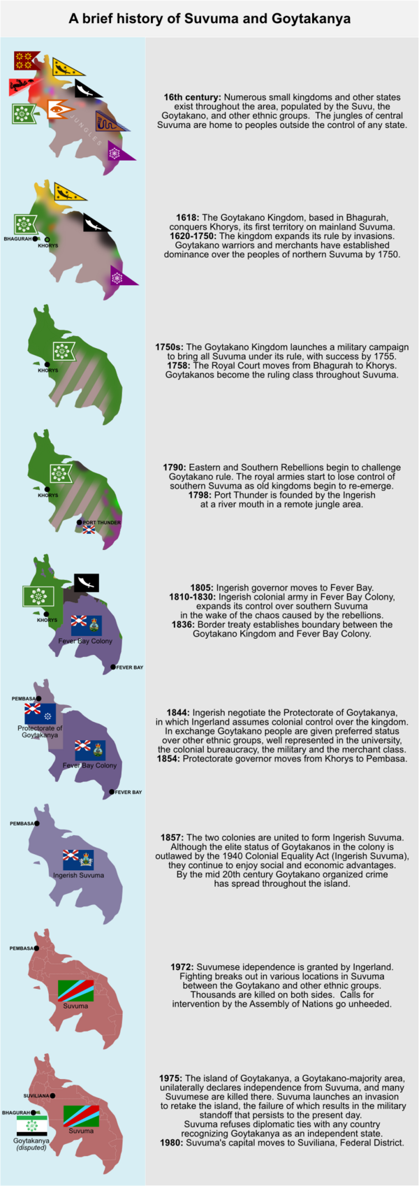
The preliminary sketch for the territory's late history is shown here:

Things to be decided as the project unfolds
Those that participate in the mapping will be encouraged to help 'fill in the blanks' with history, government, and territorial development. For example, a list of historic figures will be needed to populate historic sites, manors, and municipal toponymy. Positions of other historically fortified settlements in the 'interior' of the country will also be needed. Other elements that need to be determined will be addressed as they arise with mappers that are active in the territory.