Collab:Valonne

|
Valonne is an official collaborative territory, coordinated by Aiki and Bixelkoven. Mapping in this territory is primarily done in French. Valonne is inspired in part by France. This project is open for new mappers at this present time. Please see the page below for more information and to sign up. |
| FR - Ceci est la page d'information du projet collaboratif Valonne. Les discussions concernant le projet se trouvent sur sa page Forum. EN - This is the information page for the Valonne collaborative project. The discussions regarding the project are located on its Forum page. |
| La Valonne, anciennement connu sous le nom de Franqueterre, est un territoire collaboratif situé au centre de l'Ulèthe de l'Ouest. Inspirée de la France métropolitaine, elle sert de patrie à l'équivalent de la langue française dans OGF, connue sous le nom de « Valonnais » et à la Culture française. Le coordinateur actuel du projet est Aiki (par intérim), les administrateurs régionaux aidant également au projet. | Valonne, or Valony as known in English (previously known as Franqueterre), is a collaborative territory located in central West Uletha. Modeled after Metropolitan France (see: Metropolitan France on Wikipedia), it serves as the homeland for the French language equivalent in OGF, known as Valonian and the French culture. The current project coordinator is Aiki (acting), with the regional admins also helping with the project. |
Information essentielles / Basic information
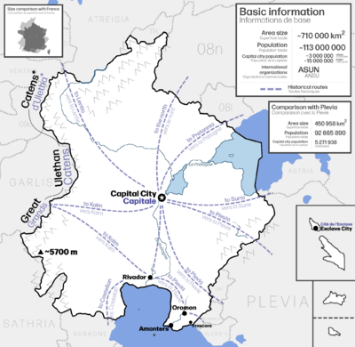
| Semblable à son homologue e dans la réalité, la Valonne était autrefois une puissance coloniale possédant des colonies sur presque tous les continents du monde OGF. Elle reste très influente tant à Ulèthe de l'Ouest qu’à l’échelle mondiale, sur les plans économique, politique et culturel. La Valonne est située au centre du sous-continent d’Ulèthe de l'Ouest, ce qui lui a permis d’exercer, jusqu’à nos jours, une influence significative sur ses voisins voire audelà. Avec une superficie de plus de 700,000 km2, c'est l'un des plus grands pays d’Ulèthe de
l'Ouest et du monde. La Valonne s’étend également sur une partie du cœur de l'équivalent OGF de l'Empire romain. Ce sujet est actuellement en cours de discussion au sein de la communauté OGF, et plus d'information peut être trouvée sur le article du forum à ce sujet. |
Similar to its real-world counterpart, Valonne was once a colonial power with colonies on nearly every continent in the OGF world. It remains highly influential both in West Uletha and globally, economically, politically, and culturally. Valonne is situated in the center of the West Ulethan subcontinent, making it a significant influence on its neighbors and beyond, historically and in modern times. With an area of over 700,000 square kilometers, it is one of the largest countries in West Uletha and the world.
Valonne also partly includes the heart of the OGF Roman Empire equivalent. This topic is currently under discussion by the OGF community, and more information can be found at the forum post for it. |
Structure du projet / Project structure
|
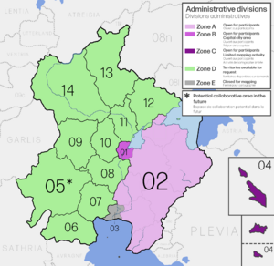
Le pays est divisé en cinq grandes zones :
|
The country is divided into five major zones:
|
| REMARQUE : Les utilisateurs souhaitant éditer dans l'une des zones collaboratives publiques doivent contacter le coordinateur du projet pour exprimer leur intérêt à y participer. NOTE: Users wishing to edit in any of the public collaborative zones must contact the project coordinator to express their interest in participating. |
| Zone A : Zone collaborative ouverte | Zone A: Open Collaborative Zone |
|---|---|
Cette zone couvre environ un tiers de l’ensemble du pays, situé dans la partie orientale. Il est divisé en huit provinces à des fins administratives, mais les utilisateurs peuvent le modifier librement dans ces provinces. Cette zone étant limitrophe du projet collaboratif de Plevie, les utilisateurs doivent contacter les membres actifs de ce projet pour coordonner les zones frontalières. Cette zone devrait présenter un mélange équilibré de cartographie urbaine et rurale, avec une densité de population plus élevée dans les parties ouest et sud. |
This zone covers roughly one-third of the entire country, located in the eastern part. It is divided into eight provinces for administrative purposes, but users can edit freely across these provinces. Since this zone borders the collaborative project Plevia, users should contact active members of that project for coordinating border areas. This zone should feature a balanced mix of urban and rural mapping, with higher population density in the western and southern parts. |
| Zone C: Zone des territoires extérieurs | Zone C: Outer Territories Zone | ||
|---|---|---|---|
Comme les zones précédentes, la Zone C est ouverte aux utilisateurs intéressés. Il comprend deux zones d'enclave situées à l'écart du continent Valonne mais toujours à l'ouest d'Uletha. Chacune de ces zones est une province individuelle :
|
Like the previous zones, Zone C is open to interested users. It includes two exclave areas located away from mainland Valonne but still in West Uletha. Each of these areas is an individual province:
|
| Zone E: Zone collaborative de Rivador | Zone E: Rivador collaborative zone |
|---|---|
Cette zone englobe la ville de Rivador∈⊾ et ses environs immédiats, situés au sud. Elle contient des cartes offertes par Le Mathou. En raison de préoccupations politiques récentes concernant la cartographie, les coordinateurs ont décidé de supprimer progressivement la cartographie de toute la ville et de la remplacer par une nouvelle cartographie actualisée, ce qui impliquera également la communauté. Pour participer, contactez les administrateurs de la collaboration. La zone en cours de remaniement est visible sur le lien suivant : Lien. |
This zone encompasses the city of Rivador∈⊾ and its immediate surrounding, located in the south. It contains mapping donated by Le Mathou. Due to recent policy concerns regarding the mapping, the coordinators have decided to slowly remove the mapping of the entire city and replace it with new and fresh mapping, and this will involve the community as well. To participate, contact the collab administrators, whereas the current area undergoing rework can be seen on the following link: Link. |
La participation au projet / Joining the project
Rejoindre le projet - territoire collaboratif Les zones A, B et C sont ouvertes à tout participant. Contactez le coordinateur au lien suivant pour rejoindre le projet: Lien |
Joining the project - collaborative Zones A, B and C are open to participants. Contact the coordinator at the following link to join the project: Link |
Rejoindre le projet - territoire privé La zone D présente des territoires que les utilisateurs peuvent demander, que ce soit en tant que territoire collaboratif ouvert ou fermé. Avant de demander un territoire, assurez-vous que vos plans correspondent aux plans présentés sur cette page. La demande d'un territoire se fait de manière standard. Vous pouvez voir les territoires disponibles sur la Page de présentation des territoires. |
Joining the project - private territory Zone D features territories that users may request, whether as a single owner or as a private/public collaborative. Before requesting a territory, make sure your plans are matching to the plans on this page. Requesting a territory is done the standard way, you can see the available territories on the Overview page. |
Plans à l’échelle nationale et collaboration entre utilisateurs / Nation-wide plans and user collaboration
| Il existe certaines directives que tous les utilisateurs doivent suivre: | There are certain guidelines that all users need to follow: |

|
Langue Le pays doit être cartographié exclusivement en langue française. |
Language The country should be mapped exclusivelly in the French language. |
Communication Communiquez avec les autres utilisateurs participants, notamment au sein des zones collaboratives ouvertes. Si vous souhaitez proposer l’ajout d’éléments importants, veuillez d'abord contacter le reste de la communauté ! Les discussions se trouvent sur la page Forum du projet. |
Communication Communicate with other participating users, particularly within the open collaborative zones. If you'd like to propose any significant features, please contact the rest of the community first! The discussions are located on the project's Forum page. |

|
Directives Assurez-vous de suivre les directives continentales de la page OGF:Ulèthe de l'Ouest. |
Guidelines Make sure to follow the continental guidelines from the OGF:West Uletha page. |
Informations géographiques / Geographic information
Topographie / Topography
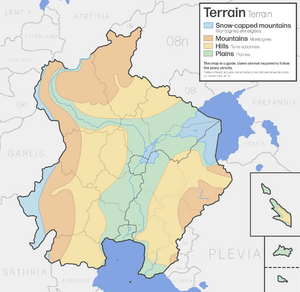
| La topographie de Valonne est relativement simple. Les frontières ouest et est sont principalement composées de chaines de montagnes, la première étant l'une des plus hautes d'Ulèthe de l'Ouest. La majeure partie du pays est composée de plaines et de collines
|
The topography of Valonne is pretty simple. The western and eastern borders are primarily composed of mountains, the former being one of the highest mountains in West Uletha. Most of the country is composed of plains and rolling hills.
|
Paysage / Landscape
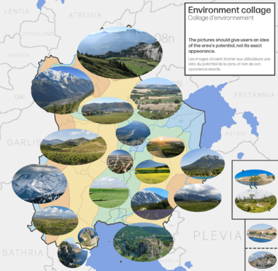
En tant que grand pays, la Valonne s'étend sur plusieurs biomes. Plus particulièrement, la majeure partie du pays se situe dans la zone tempérée continentale. Les côtes sud bénéficient d'un climat méditerranéen et les régions du nord-ouest ont un climat montagnard, semblable à celui des Alpes. Par rapport à l’Europe, elle s’étend au nord jusqu’au Danemark et au sud jusqu’à la Slovénie.
En raison de la géographie imaginaire du pays, les zones ouest, nord-ouest et sud-ouest pourraient être incroyablement venteuses en raison des potentiels vents catabatiques (potentiellement du föhn) formés par l'air descendant le long des frontières ouest. |
As a large country, Valonne spans several biomes. Most notably, most of the country lays in the continental temperate zone. The southern coasts boast a Mediterranean climate and the northwestern regions have a mountainous climate, similar to that of the Alps. Comparative to Europe, it spans as far north as Denmark, and as far south as Slovenia.
Due to the imagined geography of the country, the western, northwestern and southwestern areas might be incredibly windy due to the potential katabatic (potentially föhn) winds formed by the air descending down the large mountain chain on the western borders. |

|
Histoire / History
| La Valonne a été imaginée comme un État très puissant tout au long de son histoire. Elle occupait de vastes territoires, principalement dans la grande plaine où elle se situe actuellement. Les montagnes des deux côtés de la frontière servaient probablement de barrières naturelles contre les conquêtes et de principal système de défense contre les menaces étrangères. En raison de sa situation centrale et de son environnement entouré d'autres puissances uléthanes, la Valonne a probablement passé une partie non négligeable de son histoire à mener des guerres et des féroces batailles contre ces puissances voisines, notamment contre le Kalm et la Plévie.
À un moment donné de son histoire, La Valonne faisait partie de l’immense équivalent OGF de l’Empire romain OGF. Dans une histoire plus récente, elle a compté de nombreuses colonies à travers le monde, toutes désormais indépendantes. On ne sait pas pour quel côté la Valonne a pris parti lors de la Grande Guerre. |
Valonne has been envisioned as a very powerful state throughout most of its history. It occupied vast areas, primarily in the large plain where it is currently located. The mountains on both sides of the border likely served as natural barriers against conquest and as the main defense system against foreign threats. Due to its central location and being surrounded by other Ulethan powers, Valonne probably spent a significant portion of its history fighting fierce wars and battles with these neighboring powers, notably against the Kalm and Plevia.
At one point in history, it was part of the massive OGF Roman Empire equivalent. In more recent history, Valonne had numerous colonies worldwide, all of which are now independent. It is unknown which side did Valonne take in the Great War. |
Relations internationales / International relations
| Valonne est un membre clé de ANSU, une organisation économique internationale d'Ulèthe de l'Ouest. | Valonne is a key member of ASUN, an international economic organization in West Uletha. |
Changement de nom / Name change
| Le nom original de ce pays était Franqueterre. Le 22 septembre 2024, le nom a été changé pour le nom actuel. Vous pouvez trouver plus d'informations concernant le changement de nom sur : Link
Si vous avez cartographié des objets, qu'il s'agisse de magasins ou de territoires entiers, dont le nom comprenait le terme Franqueterre, il vous est fortement conseillé de le modifier pour qu'il corresponde au nom actuel du territoire. |
The original name of this country was Franqueterre. On the 22nd of September, 2024, the name was voted to be changed to the present name. You can find more info regarding the name change at: Link
If you have mapped any objects, whether shops or entire territories which included the term Franqueterre in the name, you are highly advised to change that to match the current name of the territory. |
Administration / Administration
| Terr. code | Prov. code | Nom / Name | Centre adm. / Adm. centre | Région / Region | Propriétaire / Owner | Taper / Type |
|---|---|---|---|---|---|---|
| UL08c-01 | NE | Nemans∈⊾ | Nemans | Région de Nemans∈⊾ | Aiki; Bixelkoven | Open collaborative (Zone B) |
| Fait partie de / Part of UL08c-02 | MA | Maroche∈⊾ | Sartres | Région Est∈⊾ | Aiki; Bixelkoven | Open collaborative (Zone A) |
| Fait partie de / Part of UL08c-02 | CL | Clairanie∈⊾ | Valcourt | Région Est∈⊾ | Aiki; Bixelkoven | Open collaborative (Zone A) |
| Fait partie de / Part of UL08c-02 | SU | Sourillac∈⊾ | La Merse | Région Est∈⊾ | Aiki; Bixelkoven | Open collaborative (Zone A) |
| Fait partie de / Part of UL08c-02 | CS | Cascagnet∈⊾ | Bourderoi | Région Est∈⊾ | Aiki; Bixelkoven | Open collaborative (Zone A) |
| Fait partie de / Part of UL08c-02 | VT | Valterre∈⊾ | Rougain | Région Est∈⊾ | Aiki; Bixelkoven | Open collaborative (Zone A) |
| Fait partie de / Part of UL08c-02 | SY | Surricy∈⊾ | Anthrace | Région Est∈⊾ | Aiki; Bixelkoven | Open collaborative (Zone A) |
| Fait partie de / Part of UL08c-02 | SM | Selamane∈⊾ | Amonters | Région Est∈⊾ | Aiki; Bixelkoven | Open collaborative (Zone A) |
| Fait partie de / Part of UL08c-02 | SF | Sélonie-Flamain∈⊾ | Saint-Boniface | Région Est∈⊾ | Aiki; Bixelkoven | Open collaborative (Zone A) |
| UL08c-03 | VE | Véroulie∈⊾ | Rivador | Région Ouest∈⊾ | Aiki; Bixelkoven | Open collaborative (Zone E) |
| Fait partie de / Part of UL08c-04 | Libérie∈⊾ | Taires | Région Extrême-Sud∈⊾ | Aiki; Bixelkoven | Open collaborative (Zone C) | |
| Fait partie de / Part of UL08c-04 | Territoire du Détroit∈⊾ | Castelnau-la-Vèle | Région Extrême-Sud∈⊾ | Aiki; Bixelkoven | Open collaborative (Zone C) | |
| UL08c-05 | Unnamed province∈⊾ | Région Ouest∈⊾ | Aiki; Bixelkoven | Open collaborative (Zone D) | ||
| UL08c-06 | Unnamed province∈⊾ | Région Ouest∈⊾ | Vacant | Territory available for request | ||
| UL08c-07 | Firanie∈⊾ | Frandis | Région Ouest∈⊾ | Bulest | Territory owned | |
| UL08c-08 | Unnamed province∈⊾ | Région Ouest∈⊾ | Vacant | Territory available for request | ||
| UL08c-09 | Unnamed province∈⊾ | Région Nord∈⊾ | Vacant | Territory available for request | ||
| UL08c-10 | Unnamed province∈⊾ | Région Nord∈⊾ | Vacant | Territory available for request | ||
| UL08c-11 | SO | Sollérs∈⊾ | Sarbourg | Région Nord∈⊾ | Vacant | Territory available for request |
| UL08c-12 | Thérisie∈⊾ | Arpigny | Région Nord∈⊾ | Sweetykid | Territory owned | |
| UL08c-13 | Unnamed province∈⊾ | Région Nord∈⊾ | Vacant | Territory available for request | ||
| UL08c-14 | Unnamed province∈⊾ | Région Nord∈⊾ | Vacant | Territory available for request |
The following table shows every administrative division in the country and their respective tags. Mappers are obliged to follow the tagging rules used for each administrative level.
| Adm. level | Description |
|---|---|
| 2 | The entire territory of Valonne∈⊾ (continent + enclaves d'outre-mer / mainland + overseas exclaves) |
| 3 | Régions - 5 total |
| 4 | Provinces - 20 total |
| 6 | Départements - à la discrétion de chaque utilisateur / up to each user |
| 7 | Arrondissements - à la discrétion de chaque utilisateur / up to each user |
| 8 | Communes - à la discrétion de chaque utilisateur / up to each user |
| 9 | Arrondissements municipaux (dans les grandes villes / in large cities) - à la discrétion de chaque utilisateur / up to each user |
| 10 | Quartiers - à la discrétion de chaque utilisateur / up to each user |
Participants actuels / Current users
| Utilisateur / User | Zone / Area | Rôle / Role |
|---|---|---|
| Bixelkoven | Administrateur régional Regional admin | |
| Sweetykid | Zone A, B, C | Contributor |
| Mantan | Zone A, B, C | Contributor |
| Geoc3ladus | Zone A, B, C | Contributor |
| ante44 | Zone A, B, C | Contributor |
| sergjack | Zone A, B, C | Contributor |
| varnel_maiser | Zone A, B, C | Contributor |
| newflanders | Zone A, B, C | Contributor |
| Paul Pfh | Zone A, B, C | Contributor |
| Aiki | Zone A, B, C | Coordonnateur de projet Project coordinator |
| stjur | Zone B | Contributor |
| sudo91 | Zone B | Contributor |
| Bulest | Zone D | Propriétaire du territoire Territory owner |
| Sweetykid | Zone D | Propriétaire du territoire Territory owner |


