Forum:Ingrea/Capital city
The capital city of Ingerland is located in the eastern part of the country, in the region #14∈⊾, being the administrative, cultural and economic center of the nation. It's designated as a collaborative territory meaning everyone interested is welcome to contribute. However, to prevent the city from being mapped chaotically and to allow it to grow naturally, the city should be planned thoroughly in this section before anything is mapped.
| NOTE: The capital should not be based directly off London. The city should have some distinct and unique characteristics. Nevertheless, London is welcome as an inspiration. |
What to discuss:
And various other aspects, bits and pieces... |
User proposals
Sudo91's proposal:
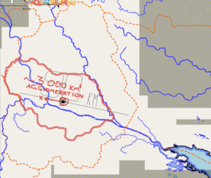
| At first, I would like to point out the suggested size for the capital. It will, of course, depend on how many people will live in Ingerland proper. If we take the population density of IRL UK (270/sq.km), Ingerland would have 139 mln. people. Although, I doubt that such population density is possible at such high latitudes, nor it can be as low as Scottish (67/sq.km). For my calculations down below, I took the population density of 150/sq.km. and got the supposed population of Ingerland at 77 310 000. (UK has 67 mln)
Whatever the case, we probably should keep the population density of Winburgh (I would also like to keep the same name; there are myriads of objects all around OGF named after Winburgh) around the same as London (5500-6000 per sq.km.) and the city area may accomodate 1500-2000 sq.km in total.
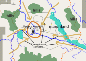
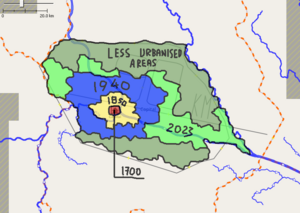
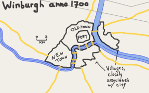
Location within capital regionThe capital should, of course, be placed along the river. I shifted the "centre" location to the position on the left because I believe it looks more defendable: rivers cut the access to the fort at three sides, and on the fourth side there are hills. Later on, the development of industry may lead to mass building at more flat areas, such as where "capital" marker is located on OGF at the moment. Geography of the regionHere is an another map featuring main obstacles that would play key role in city's strategic position -- hills and marshes. Most of the marshes would be gone by the present day, and hills were turned into national parks or natural reserves. Historical growthHere's the sketch map on how the growth will go. The city's size before 1700 was quite negligible.
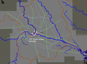
Population/sizeI would estimate the capital agglomeration's population at 8 mln - 11 mln. The capital region area's population should not exceed 15 mln people. I also have this very crude map of main railways (excluding local ones) and main motorways in agglomeration. My proposal is probably too early since we don't have main transport corridors planned. |
Discussion
The northeastern and the southern part of the capital region could be hilly as there are rivers from adjacent regions kinda originating in those locations. As a center of culture, economy, and administration, population could be at least 10% of the total population of Ingerland. In infrastructure, there could be a symmetrical layout of a palace surrounded by gardens as the seat of government, or castles that are now museums. Senju (talk) 02:11, 1 May 2023 (UTC)
I really don't want the capital to be called Winburgh - it is such an ugly name that's also not very typical of English naming conventions (it's much more like Edinburgh which is Scottish). Winburgh can stay as a decent sized city in the north. Gubble (talk) 16:39, 5 May 2023 (UTC)
- There's absolutely nothing wrong with "burgh" from an etymology perspective: "Burh and burg were Old English developments of the Proto-Germanic word reconstructed as *burg-s, cognate with the verb *berg-an[1] ("to shut in for protection").[2] They are cognate with German Burg, Dutch burcht and Scandinavian borg and, in English, developed variously as "borough",[1] "burg",[3] and (particularly in the East Anglian region of England and Scotland) "burgh".[4]" (from wikipedia:Burh#Name) /wangi (talk) 10:15, 24 November 2023 (UTC)
Name
Shall we try and get a name assigned to the capital city by the end of this year? I would suggest that we invite suggestions over a three-week period and then vote over the following couple of weeks so that we have a decision by the end of the year. Anyone should be welcome to submit ideas but the decision will be made by Ingerland mappers.
If there are no objections, I'll start a proposals list in a couple of days with a submission deadline of 14th December. Pawl (talk) 11:56, 21 November 2023 (UTC)
Proposals
If you have any proposals for a name for the capital of Ingerland, please add them below by 14th December.
| Num | Name | Comments |
|---|---|---|
| 0 | Winburgh | Transfer the name from the previous capital. Etymology: wentā (from a common Celtic word meaning "tribal town" or "meeting place") + burgh (Old English, fortified settlement) |
| 1 | Andon | A nod to Andy, the creator of the original Ingerland. In-world, it could be named after the city's founder, e.g. Andreus |
| 2 | Anditon | |
| 3 | Reydon | Already the name of a city outside of Winburgh, which was utilised by me as the etymology of the provincial capital for Ingerish Asperia. However, I think it would work well as the name for the capital. Obvious disadvantage is the similarity to “London” - but people can decide on that. Etymologically, I also think it would work as it could be derived from the Latin “regium oppidum” which translates to “royal town”. Arlo (talk) 23:33, 1 December 2023 (UTC)Arlo |
| 4 | Boldon | From the name of the local Celtic tribe - something like Bolcanae? Pawl (talk) 11:11, 8 December 2023 (UTC) |
| 5 | Eastminster | Minster in the east :-) Pawl (talk) 11:11, 8 December 2023 (UTC) |
| 6 | Dominster | Contraction of "lord's castle/fort" Domini castrum, castrum > caester (OE) > chester. Pawl (talk) 11:11, 8 December 2023 (UTC) |
| 7 | Rexton | Town of the King. An alternative to number 3, which I think sounds too much like the radioactive gas Radon! Pawl (talk) 11:11, 8 December 2023 (UTC) |
| 8 | Drenham | Perhaps the river can be the River Drenn so this could mean something like village on the Drenn or land in the riverbend of the Drenn Ruadh (talk) 08:56, 23 December 2023 (UTC) |
| 9 | Dinester | Perhaps related to Celtic dunon hill/fort and Old English ceaster town Ruadh (talk) 08:56, 23 December 2023 (UTC) |
| 10 | Keliston | Kell's town/stone Ruadh (talk) 08:56, 23 December 2023 (UTC) |
| 11 | Rother/Rothe | Landing place Ruadh (talk) 08:56, 23 December 2023 (UTC) |
| 12 | Wendon | https://en.wikipedia.org/wiki/The_Great_Wen Ruadh (talk) 23:37, 27 December 2023 (UTC) |
There's quite a list of names there! Could we narrow it down by choosing our favourites, or our top two or three? I think my top two are Dominster or Wendon. But there are only about three I definitely don't like. Pawl (talk) 08:26, 12 January 2024 (UTC)
- My personal preferences would go to keeping Winburgh, or using Dominster, Rexton, or Rother/Rothe with the stipulation there that using Rother/Rothe would require a suffix like -ster, -ton, -don, etc. For me, that would be Rothedon. -- Aces California (talk) 17:12, 12 January 2024 (UTC)
- Okay if I'm going to nominate a few for a vote, in no particular order, Wendon, Dominster and Rexton. Ruadh (talk) 13:11, 21 January 2024 (UTC)
- My votes are for Dinester (or something like Dinecester if you want to confuse people with pronounciation), Rothe, and Wendon. In general I'd prefer something somewhat unique-sounding and not too reminiscent of London. Yuanls (talk) 12:33, 27 January 2024 (UTC)
Name selection
| Ingerland mappers: Please choose your preferred and an alternate option for the capital city's name. Please note that names not chosen for the capital proper can be reused for other various prominent localities in the country, whether it be for other major cities, royal residencies, seats of government, etc. Additionally, the name "Winburgh" is going to be preserved for the existing city. This choice is for the new capital and will not effect the original city. — Alessa (talk) 21:09, 10 February 2024 (UTC) |
It would be good to get this settled ...
Can I propose that we take the four names which were chosen more than once and each list our first and second choices? If nothing gets a majority of first choices we can add second choices to the totals, and if there's a tie, we can have a runoff vote with only the top two.
The four with multiple selections were:
- Dominster
- Rexton
- Rothe
- Wendon
We could still utilize losing names for things like the main government borough within the capital (like Westminster) or the location of a major royal castle or palace outside the capital (like Windsor).
If people are agreeable to going ahead this way, my choices are 1) Wendon, 2) Dominster. - Pawl (talk) 09:15, 10 February 2024 (UTC)
Wendon would be my preference. Rexton probably second preference. Myrcia (talk) 18:41, 26 March 2024 (UTC)
My preferences would be Rexton first, then Dominster second. Relegate Rothe to a local area, or name of a river, until it's decided if/and what suffix can be added to it. I still believe Rothe+suffix would make for a good place name non-the-less. --Aces California (talk) 08:36, 29 March 2024 (UTC)
Wendon first, then Dominster, would be my preference. Ruadh (talk) 19:45, 5 April 2024 (UTC)
There's still one person to vote, but with three first-preference votes out of a possible five I guess Wendon is the winner. We can still use all the other three in some capacity. - Pawl (talk) 09:54, 10 April 2024 (UTC)
- Just confirming so I make the necessary updates on the map (and my own wiki), have you all agreed to go with Wendon as the name for the capital city? Turnsole80 (talk) 07:54, 26 May 2024 (UTC)
Planning the capital city. Initial sketches and suggestions
Here's my sketch for the old town. It's far from finished, but can be used as a basis for the further mapping.
Sudo91 (talk) 09:52, 17 May 2024 (UTC)
General agglomeration maps and plans
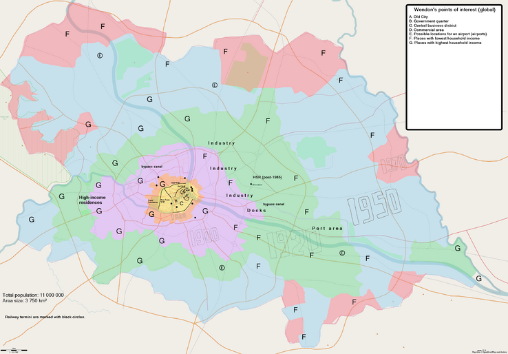
Here's the map I drew today. It doesn't show much (yet) aside from main motorways, streets in the city centre, and main point of interest. In general, it inherits a lot of influence from my previous plan from May 2023 that you can see above.
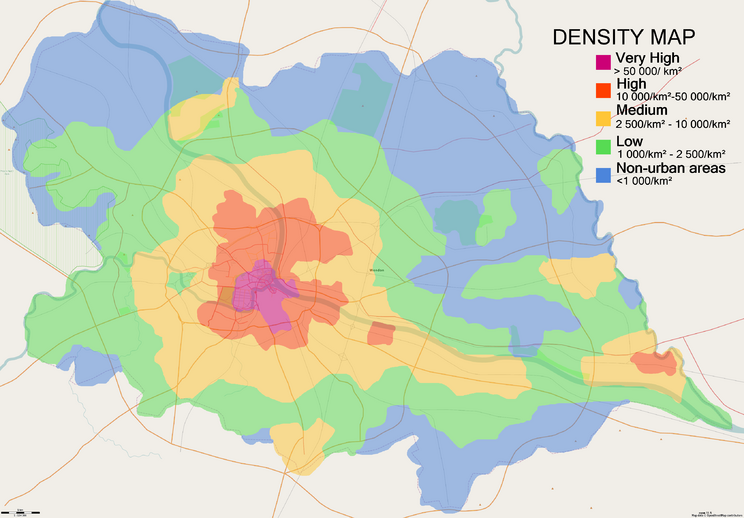
And this is another map that shows the density in Wendon conurbation.
Sudo91 (talk) 03:48, 21 May 2024 (UTC)
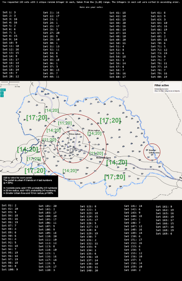
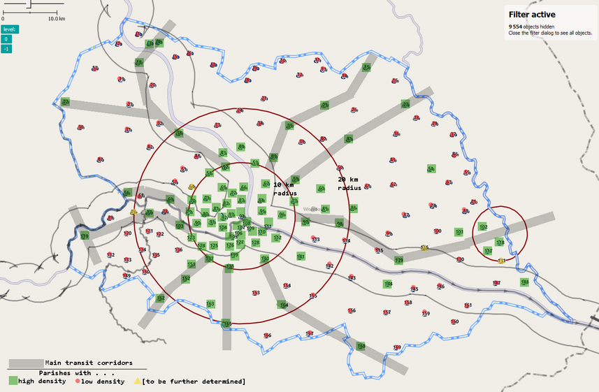
A small update about the density in Wendon: varnel_maiser suggested to randomly assign "density status" for each of 169 sporadically ditributed parishes (provisional name for a subdivision of Wendon), and here's what I got.
First picture depicts the method of assigning a density status, the second one shows the results.
-- Sudo91 (talk) 10:38, 26 May 2024 (UTC)
Discussion of Sudo91's proposal
I'm happy to favour this current proposal, considering its advanced detailing and the lack of any other submissions. Broadly speaking I'm happy with the first-order sketches presented. Yuanls (talk) 22:13, 27 May 2024 (UTC)
One thing I'd highlight about the Wendon plan is that the trunk road system is a lot more well-developed than London (or really any British city). This diverges quite substantially from modern British urban planning because many of these 1950s-80s road building projects, e.g. the London Ringways plan, were never fully realised. N.b. this is neither a criticism nor an approval of the road layout - I am merely highlighting my observations for further discussion if required. Yuanls (talk) 22:13, 27 May 2024 (UTC)
I'd also like to raise the point about the area 'outside' of Wendon proper, but still within the boundaries of UL10-14. Historically London and other UK cities have grown relatively little in the past half century (probably even less than the red area on the new Wendon plan from the wiki page), because of the creation of the 'green belt' which limited suburban sprawl. Instead in the UK, we have a ring of large, high-income commuter towns within and outside the green belt. Are we planning to replicate something similar here? Or perhaps because of Ingrea's large size there was less concern about urban sprawl and so we could potentially make the most modern suburbs larger, but less dense? Again, it would be good to hear everybody's thoughts. Yuanls (talk) 22:13, 27 May 2024 (UTC)
- I like how Sudo91's proposal renders the feeling of gigantism of London's urban sprawl. I noticed that both current rivers were quite wide (~300m/1000ft for the smaller one to ~650m/2100ft for the larger one). If they are kept as such, I suppose this might have somehow hindered the development on the opposite bank. Maybe the existence of some market towns, that developed over the centuries, some 10-15km (5-10mi) from the Old Town, before being incorporated in the larger urban area, may explain the situation. They may still work as secondary city centres today. I'd tend to agree with Yuanis regarding the absence of a very-British green belt or large parks (e.g. former royal hunting grounds like Richmond Park) that channelled urban development. Apart from these few points that made me wonder, I feel the drafts are fairly appealing.
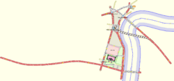
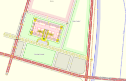
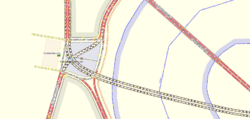
- For some reasons, some of these reflections focused on how the Ingrean Parliament Building may look like as to not be too similar to the Palace of Westminster. Here is a draft, based on Sudo91's maps. You may reuse the whole thing, parts of it or nothing at all (.osm file available):
--Aiki (talk) 18:58, 1 June 2024 (UTC)
- Over last summer, I did a few additional offline edits to the original file (I've just uploaded updated print screen). As I'm doing a bit of a clean up of my laptop? I was wondering if there was any interest in the features before it the file goes down the rubbish bin, whether for Wandon or somewhere else in the Ingrean Empire. Though a rather basic draft, roads' pattern or some of the buildings could be of some use. --Aiki (talk) 09:18, 12 February 2025 (UTC)
