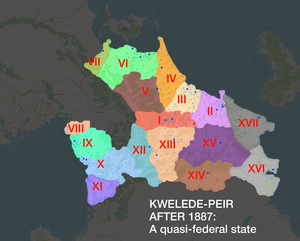
Forum:Territory application/AN152g (Kwelede-peir) - Moving to Central Antarephia (AN148)
AN148∈⊾ - Kwelede-peir moved from AN152g
Backstory and general motivation
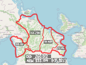
Since October 2020, I wanted to have an Antarephian country that was named "Kwelede-peir". I've drawn a few sketches for it in a location that was soon (ca. March 2021) occupied by another user. Then, I changed the location to what's now AN152g but was unsatisfied with it ever since. It was smaller than I wanted Kwelede-Peir to be and it was located too south, which resulted in harsher climate for the country.
Here is my suggestion for new location of Kwelede-peir.
| Physical geography | |
|---|---|
| An overview of climate, topography and landscape of the country. It is advised to also create a sketch, you can add a link to this (hosted on imgur or similar) |
Geology. Orogeny
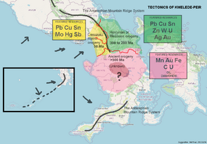
Currently, there is no consensus about how the tectonics and geology of OGF world should look like; though, that is crucial for finding out which resources can be mined there.
Here is my proposal about orogeny; the east coast should have more "smoothened" and slightly older mountains and coal mining could be possible in the southeast. Oil and gas may be drilled either in the southeast or off-shore in the EEZ.
Climate
The climate would be temperate, either Cfa/Cfb or Dfa/Dfb. The average temperature span will be -10C to 30C on the west coast, -15C to 20C in the interior and -10C to 25C on the east coast.
Hydrography
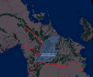
The current rivers' alignment was done really good and I would like to keep it and base my mapping on it. The main routes in the country would probably be built along this main river, and then to the west coast.
 | Human geography |
|---|---|
| A brief description of the territory demographics, economic development, land occupation, infrastructure and mapping style |
Connections
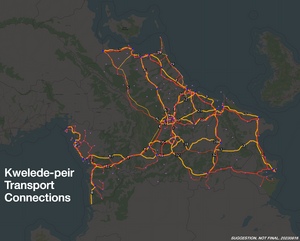
I attached the rail/road map, respectively.
Economy
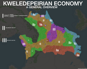
Kwelede-peir is a newly developed country and 30% of the economy is still oriented at its primary sector. Secondary and tertiary sector are presented in the economy at 40% and 30% of GDP, respectively.
The economy can be described as a dirigist mixed system, where major and heavy industry is owned by state entirely and follows plans and directives that are developed on a general meeting of economists and business owners. Medium and small businesses are mostly privatized and run by market laws.
Infrastructure and land occupation
Energy and power
Kwelede-peir gets its energy primarily from hydro (including tidal) and thermal power plants. Nuclear power plants started to appear after 2006 when country joined the Antarephian Coalition.
Public transport
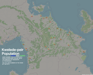
Due to the oil shortages in the past, the car was seen as a luxury item for many Kweledepeirians. Because of that, public transport is fairly developed and covers a significant portion of the country.
Land
Land outside of the cities and big municipalities is usually privately owned (think latifundias in Latin America). State-owned land is common in the villages that still have collective farms left from the socialist era.
City planning
City grid in downtowns is usually "colonial": 100*100 metre (or 88m*88m before metric system) squares plopped together for as long as the may. During socialist era (late 1940s to 1971) and from 1971 to mid-2010s, a lot of public housing was built, so Soviet-like microdistricts are also present in the cities. The villages are built irregularly, often as a single street with side streets branching off.
| History & culture | |
|---|---|
| A brief description of the intended culture and language |
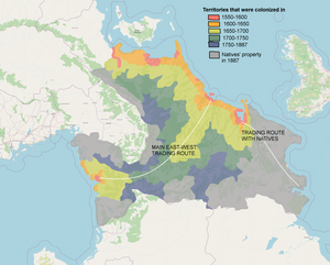
Kwelede-peir is, historically, a union of multiple colonies and tradeposts of Ulethans from one side and a Natives' Domain from another side.
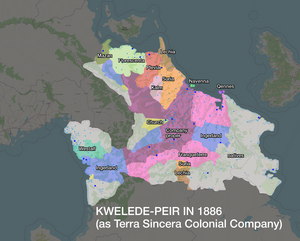
First Ulethan settlements start to appear in 1590s and a colonial trading company was founded in 1689. That company, de-jure, owned the land and the countries were its shareholders.
The colony shipped mainly ores and fur to the Uletha. Due to conservative policies of colonial government and lack of industrialisation, local bourgeoisie staged a coup against it, proclaiming Kwelede-peir a republic on 1886, March 21. The civil war lasted until 1 February 1887 and resulted in the victory of Republicans.
Due to close contacts between the various colonists, a pidgin language was formed around early XIX century. It gained an official status after 1887 Revolution.
In 1915, another revolution happened, this time it was made by left-nationalist forces that stood on the %bad_guys_side_who_lost% in the Great War. That's why by mid-1950s Kwelede-peir started its isolationist policies; socialists took power and isolated the country until 1971 when the natives alongside the military forces staged a coup which wasn't supported by people and in 1974 the reformed socialist government returned and set the country on the path of slow democratisation, which led to Kwelede-peir opening to the world in 1988 and joining that Antarephian Coalition in 2006.
(You may think that there are too many coups, but countries' histories outside global North sometimes do be like that.)
| Past mapping | |
|---|---|
| To support your request provide links to areas of OGF mapping which showcase your mapping skill. Mapping relevant to the requested theme & geography is especially useful | |
| The {{coord}} template can optionally be used to link to the OGF map - it results in a nice formatted link. Or you can paste in a URL. |
Here are some bits of my mapping over the past ~1.5 years.
2023
- Little Bay @ Kingstown, Deodeca (urban, detailed) https://opengeofiction.net/#map=15/-42.5321/139.2587&layers=B
- Antronos @ Weldoslendo (urban, detailed) https://opengeofiction.net/#map=16/60.3894/62.6921&layers=B
- Karpomori @ Weldoslendo (suburban) https://opengeofiction.net/#map=15/60.6653/61.6252&layers=B
2022
- Kitegos @ Weldoslendo https://opengeofiction.net/#map=15/60.7416/62.3490&layers=B
- Mont Dignitus @ KP (urban) https://opengeofiction.net/#map=14/-58.4210/50.8835&layers=B
- Franardal @ KP (urban) https://opengeofiction.net/#map=18/-60.96969/47.22285&layers=B
- Bana-Sunpora @ KP (urban) https://opengeofiction.net/#map=16/-59.1015/50.0627&layers=B
- Koltushev @ Suria (detailing pre-existing street grid, urban, rural) https://opengeofiction.net/#map=16/40.4484/90.8181&layers=B / https://opengeofiction.net/#map=16/40.4259/90.7526&layers=B
- Bastionnoye @ Suria (rural, nature, resort) https://opengeofiction.net/#map=14/40.2879/89.6581&layers=B
| Username & date | |
|---|---|
| Sign and date the application by typing four tildes like this: ~~~~ |
Sudo91 (talk) 18:46, 16 August 2023 (UTC)
 | Discussion |
|---|---|
| Discussion for clarification & decision |
- Hi, I just want to add that User:Sudo91 discussed this plan with me and we opened up an informal conversation with User:AnimationSky. I don't have any concerns regarding this plan. We've also worked together on the Kingstown Project, and their work is amazing. --- Thanks, Zekiel (talk) 21:07, 16 August 2023 (UTC)
+++++++++++++++++++++++++++++++++++++++++++++++++++++++++++++++++++++++++++++++++++++++++++++++++++++++++++
Hi sudo91,
Thank you for your application,
- Backstory and general motivation
Thank for explaining your motivation and for Varnel maiser's input. My main concern is splitting Antarephia with a new cross-continental territory that may render any evolution, at continental level, less flexible. To a smaller extent, I'm a bit lukewarm with merging too many decent-sized territories. Please find below 2 proposals, each having its own upsides and downsides, depending on what is important to you/your territory (e.g Proposal #1 has a longer coastline facing Varnel's and Sky's territories while Proposal #2 offers a longer land border with Sky's country):
| Proposal #1 | Proposal #2 | Current Kwelede-Peir | ||||||
|---|---|---|---|---|---|---|---|---|
| Territory | Area (km2) | Coastline (km) | Territory | Area (km2) | Coastline (km) | Territory | Area (km2) | Coastline (km) |
| AN145 | 45 145 | 1 677 | AN148 | 146 983 | 1 058 | AN152g | 201 842 | 4 734 |
| AN147a | 97 097 | 656 | AN152b | 71 721 | 631 | |||
| Total | 142 242 | 2 333 | Total | 218 704 | 1 689 | |||
| Percentage of current Kwelede-Peir | 70% | 49% | Percentage of current Kwelede-Peir | 108% | 36% | |||
- Physical geography
- Geology. Orogeny
Please keep in mind the few specifics for Central Antarephia. These are not that strict except the part concerning having low mountains/hills instead of having high ones, so that Hardan Countries benefit from a milder climate than their latitudes and continental orientation would command.
- Geology. Orogeny
Please note that only territorial sea is mappeable, excluding the largest part if an EEZ.
- Climate
Fine. I would even rise the minimal values - Hydrography
As long as you keep the relation for international watercourses, you may adapt them to a reasonable extent. Please find here the relations (type:waterway) for this area. Most are mapped or reused for drawing parts of territories' borders.
- Climate
- Human geography
- Connections
Nothing to comment. - Economy
Nothing to comment. - Infrastructure and land occupation
- Energy and power: if you have a large heavy industry sector that predates the nuclear plants, I would consider having some fossil fuel power plants (coal?) to supplement hydro plants, especially if this industry is located "far" from the latter.
- Public transport: nothing to comment.
- Land: nothing to comment.
- City planning: are you considering any pre-colonial mapping style - or non-Ulethan yet contemporary of the colonial period - for your settlements?
- Connections
- History & culture
Neighbouring countries (AN142i, AN142g or Ullanyé) do not provide a lots of dated information but all have a rather mild Ulethan influence. I would suggest to have coastal main colonial outposts with more minor ones along the trade routes you suggest.
Please note that IRW, colonial enterprise was a chiefly a competition between countries (e.g. get to the resources - real or expected - for their homeland, monopolise your colony's external trade), directly or via their private companies. At a time when protectionism was central to any politics, colonial/commercial collaboration was limited to products you couldn't extract/produce yourself (usually heavily taxed) or delimiting what plot belongs to whom. I'm rather unsure an international company, as the one you suggest, could have been set up in the late 1600s.
- Past mapping
- Past mapping
Thank you for the links. They show a real progression of your mapping skills, especially those for Ward 60 in Deodeca. Do you consider transferring any mapping artefacts or current Kwelede-Peir would be purely vacated?
Kind regards, --Aiki (talk) 15:18, 19 August 2023 (UTC)
> Thank you for your response.
- Energy: abovementioned "thermo" power plants are the fossil fuel plants in question.
- City planning: if a modern settlement was built at place of an ancient Taukan or Sjepar town, its planning may be incorporated into the general street alignment. Same with Taukan/Sjepar villages.
- History and culture: Sure, I'll rewrite the part about the international company.
I will transfer only some parts of urban mapping; the rest can be cleared or left as-is.
I would go with proposal #2 then and will consider your suggestions. // Sudo91 (talk) 07:06, 20 August 2023 (UTC)
- Hi, AN148 is now yours. This is the land area relation.
- I've marked AN152g/current Kwelede-Peir for withdrawal for 30 days so that you can transfer some parts of your mapping. Please be mindful of the amount transferred and do actually move the artefacts to their new location and do not copy/paste them. Happy mapping, --Aiki (talk) 09:24, 20 August 2023 (UTC)
 |
Territory application approved |
|---|---|
| --Aiki (talk) 09:24, 20 August 2023 (UTC) | |
| As you develop your territory, be sure to keep it realistic. Here are some resources you may find useful for starting out: Help:Portal, Help:Making realistic countries, Help:Making realistic cities and OpenGeofiction:Site policies |
