Forum:Territory application/AR060-02 / Kastichetshan
- Please fill in the information below to make a territory request.
| Territory ID and proposed name | |
|---|---|
| The Territory ID (from OpenGeofiction:Territories, e.g. AR123a) and proposed name of the country |
AR060-02 / Kastichetshan
| Physical geography | |
|---|---|
| An overview of climate, topography and landscape of the country. It is advised to also create a sketch, you can add a link to this (hosted on imgur or similar) |
Kastichetshan (CAST-ee-ketch-on) is a small province within the Dominion of Deodeca. Kastichetshan sits within a temperate oceanic climate, with some northern areas of the province sitting within warm subtropical climates. As for topography, Kastichetshan features tall and rocky mountains on the western borders. Moving northeast, the land changes from tall mountains, to low rolling hills, where agriculture is present. Provided in the sketch below, there is a basic plan on natural cover and rough topography for Kastichetshan:
Kastichetshan features a few major rivers, with the headwaters originating from the rainy mountains. The rivers feature prominent and thriving agricultural regions along the Trans-Deodeca Route 1 (TDH-1) corridor.
 | Human geography |
|---|---|
| A brief description of the territory demographics, economic development, land occupation, infrastructure and mapping style |
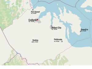
A majority of Kastichetshan ‘s population will live in the major urban centers that are shown above, most people living within Coalburne or Delbert City, and/or their respective suburban areas. The second majority of population lives along the TDH-1 corridor, given that TDH-1 is the biggest transportation corridor within Kastichetshan. Since Coalburne and Delbert City are set along the ocean, they could be potential areas for nautical ports and industrial commerce. Because they are also served by the Trans-Deodeca Highway System, they could also be potential shipping hubs within the region, especially Coalburne, with their industrial businesses and nautical shipments. The island off of the mainland, as per KAB’s suggestion, will be an island with many native reservations, with their largest city, Kaawch’sa. Many of the natives who reside on this island will mostly be classified under the Penutian tribes (I haven’t devised OGF names for any of the Penutian tribes as of this application). The rural mapping style will be inspired by rural areas of Australia and Alberta/British Columbia/Saskatchewan, considering the region Kastichetshan is in.
| History & culture | |
|---|---|
| A brief description of the intended culture and language |
Following the planning of native reserves, Kastichetshan will be an Ingerish and native-speaking province. Most of the native cultures will be found within the native reservations where the native populations are centered (most notably in Kaawch’sa and other towns within the reserves). Most of the culture within the rest of the province (i.e., Coalburne, Delbert City, Port Stewart, etc.) will come primarily from Ingerish settlers.
| Past mapping | |
|---|---|
| To support your request provide links to areas of OGF mapping which showcase your mapping skill. Mapping relevant to the requested theme & geography is especially useful | |
| The {{coord}} template can optionally be used to link to the OGF map - it results in a nice formatted link. Or you can paste in a URL. |
- Detailed Farmland that I made in the FS state of Riopoderos.
- Mountain/Ski resort town of Hanumuneeko
- Mountain town of Tennewa Springs
- Mountains #1
- Ontario Styled Rural Roads + Forest
- Shelburne Suburban Mapping
- Colurona City/Suburban Mapping
Here is a small collection of my past mapping. I will reference some of it, as well as other samples that I have not provided, in some areas around Kastichetshan.
| Username & date | |
|---|---|
| Sign and date the application by typing four tildes like this: ~~~~ |
Geoc3ladus (talk) 19:48, 9 August 2022 (UTC)
 | Discussion |
|---|---|
| Discussion for clarification & decision |
- Since you already have two territories, I worry that taking on a third project may be spreading yourself too thin. Rather than denying the application outright, I’ll recommend two options: either withdraw this application until you’ve made more progress on your existing territories (especially your Tarephian territory), or modify this territory request to indicate a swap for one of your existing territories. -TheMayor (talk) 15:37, 11 August 2022 (UTC)
- Hello there! Here is the situation on my current territories: Riopoderos is quite far along in development, but Nayina is still my top priority. Since I have this application saved in a Google Doc, I will consider withdrawing this application until I have developed sufficient mapping in Nayina (and possible Riopoderos as well), unless I am told otherwise. Since Riopoderos is far along in it's development, I am nearing/at the stage where it does not need as much attention as Nayina, which could mean that I could fit the development of this territory alongside Riopoderos and Nayina. If you suggest that I withdraw this application or make a territory swap, I will abide. -Geoc3ladus (talk) 19:36, 11 August 2022 (UTC)
- That works for me. I'll close this application for now, with the understanding that you'll resubmit down the road once you've made more headway on Nayina. (You're welcome to reopen the application at any time, especially if you change your mind and choose to request a swap instead.) --TheMayor (talk) 19:51, 11 August 2022 (UTC)
| Territory application closed | |
|---|---|
| Application suspended by user request. --TheMayor (talk) 19:51, 11 August 2022 (UTC) | |
| The following resources can be useful in building up mapping experience: Help:Portal, Help:Making realistic countries, Help:Making realistic cities and also OpenGeofiction:Site policies |


