Forum:Territory application/AR060-15 - Deodeca Province 15 (no name yet)
- Please fill in the information below to make a territory request.
Forenote: This is a collective application. Besides me (sudo91), Arlo and Lithium-Ion are also interested in mapping this territory. Probably, the mapping in this territory will be restricted to those who map in Deodeca already.
The application will be filled with more content from the interested mappers over the next few days.
| Territory ID and proposed name | |
|---|---|
| The Territory ID (from OpenGeofiction:Territories, e.g. AR123a) and proposed name of the country |
AR060-15∈⊾ - we haven't decide on a name yet.
| Physical geography | |
|---|---|
| An overview of climate, topography and landscape of the country. It is advised to also create a sketch, you can add a link to this (hosted on imgur or similar) |
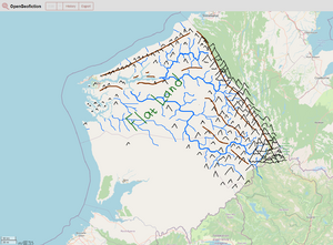
The province's landscape is hilly, with the main ridge separating it from Ingerish Asperia and Kastichetshan. The mountains in this ridge may have heights up to 4 000 m. Another ridge goes in parallel with the coastline, with heights up to 500-750 m.
Here is the sketch of how the rivers, hills and mountains may be placed in the province.
 | Human geography |
|---|---|
| A brief description of the territory demographics, economic development, land occupation, infrastructure and mapping style |
Because of the difficult terrain, the average population density reaches 20-25 people per sq. km. 1 800 000 people in the province give the number of 22.5 people/sq.km.
The economy of DE-15 is expected to be less developed than Ingerish Asperian economy, due to poorer climatic conditions.
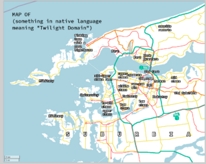
Few valleys available are already plowed, and most of the wealth is concentrated in the capital of 850 000 people (located approximately where the city of Éllé currently stands). Agglomeration of the capital (3 000 sq. km.) accommodates around 1.0-1.1 mln people.
DE-15 has strong ship manufacturing industry, and a naval base of national importance may be placed in the capital archipelago. In the province's interior, several facilities related to steel and aluminium manufacturing may be placed.
The electricity is generated mostly by hydro power plants.
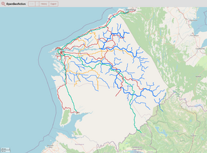
Here is the sketch of the capital area and a sketch of main roads in the province.
| History & culture | |
|---|---|
| A brief description of the intended culture and language |
The language of the province is English, with no traces of past "non-native" languages.
The native language will either be Tlingit or one of Atabascan languages spoken in British Columbia or Yukon (excluding those that are reserved for use in Ingerish Asperia).
| Past mapping | |
|---|---|
| To support your request provide links to areas of OGF mapping which showcase your mapping skill. Mapping relevant to the requested theme & geography is especially useful | |
| The {{coord}} template can optionally be used to link to the OGF map - it results in a nice formatted link. Or you can paste in a URL. |
In Deodeca: Kingstown, Ward 60 and several buildings around the downtown: https://opengeofiction.net/#map=14/-42.5345/139.2620&layers=B
| Username & date | |
|---|---|
| Sign and date the application by typing four tildes like this: ~~~~ |
Sudo91 (talk) 15:17, 23 December 2023 (UTC)
 | Discussion |
|---|---|
| Discussion for clarification & decision |
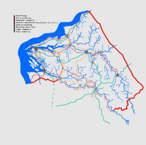
- Upon further discussion, Arlo and Lithium-Ion came up with the idea of making two big river estuaries. Here's the another sketch, with reworked river system and with cities/towns. Sudo91 (talk) 09:37, 24 December 2023 (UTC)
- TheMayor and I will discuss after Christmas. We only just opened these territories up with availability for future mappers in mind. So assigning to existing project collaborators would be a change of plan. Thanks wangi (talk) 11:45, 24 December 2023 (UTC)
As wangi mentioned, our intention in expanding Deodeca was to provide more opportunities for new mappers to join the project, rather than expanding the nation for the benefit of existing Deodeca mappers. Additionally, the three identified mappers are quite active throughout the OGF world (sudo91 currently has 4 territories; Arlo has an FSA state and oversees Ingerish Asperia; and Lithium-ion has at least 5 territories), so we do have concerns about whether or not the proposed owners will have enough time to dedicate to another project such as this. As mentioned in the pending AR060-14 application, at this time Deodeca does not warrant a third collaborative province, especially one adjacent to an active collaborative project.
All that said, since there is a lot of active motivation in Deodeca right now among a pretty close-knit group of mappers -- the precise kind of community projects like these are designed to empower and encourage, of course -- so I am proposing the following course of action:
- AR060-15 would be marked as reserved for a period of six months.
- sudo91, Arlo, and Lithium-ion would be granted access to establish the province. In this case, "establish" means the natural areas of the province can be fully mapped out, but all manmade infrastructure (including cities, farms, etc.) would be prohibited. Additional active Deodeca mappers could also assist, pending approval by sudo91, Arlo, and Lithium-ion.
- Once the natural mapping is completed or when the six month period ends (whichever comes first), the province would become a vacant "green" territory, with the requirement that any new mapper must maintain the established geography and topography of the natural areas mapped during the establishment period.
- If desired, and if activity in the other territories owned by the current team of mappers has not been negatively affected, this team can reapply for "full" ownership of AR060-15.
Please let me know if these terms are acceptable. --TheMayor (talk) 17:25, 28 December 2023 (UTC)
 |
Territory application approved |
|---|---|
| Territory request approved under the terms listed above. AR060-15 will be marked as "reserved" for sudo91, Arlo, and Lithium-ion to map natural areas. Will revisit no later than 28 June 2024. --TheMayor (talk) 23:14, 28 December 2023 (UTC) | |


