Forum:Territory application/UL22c - Fjörnåde Republikka Kåra (expansion)
| Territory ID and proposed name | |
|---|---|
| The Territory ID (from OpenGeofiction:Territories, e.g. AR123a) and proposed name of the country |
UL22c - Expansion of Kara
| Physical geography | |
|---|---|
| An overview of climate, topography and landscape of the country. It is advised to also create a sketch, you can add a link to this (hosted on imgur or similar) |
Context
The northern part of Kara is currently covered in forests and, at higher elevations, bare rock and glaciers. Much of the interior of the country is hilly and heavily forested. The majority of the population lives in the southern part of the country, particularly concentrated along the southern coastline and the Tebbjet River valley (which extends north from the capital, Kara, to Gÿrjòldbéoùyr).
Proposal
To incorporate UL22c into the country, I would make some changes to the geography of Kara's northeastern areas.
Notes on the map:
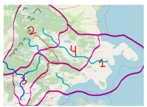
- Four general geographic regions.
- Region 1 - coastal plain. Some forests, with much of the land dominated by agriculture as well as some urban areas. Fairly flat, with land gently sloping down to meet the sea. Temperate cold maritime climate (think southern Sweden). Temperate-to-cool winters, with some of the highest areas and hills getting some snow. Temperate-to-warm summers.
- Region 2 - mountain forest. This zone would be heavily forested with largely evergreen and other cold-loving plants. A significant mountain range would extend along the northwest border. Some high-elevation areas would have tundra or glaciers. Quite similar to Kireks Lan in current Kara (the one with the rune letters). As would be expected, it has a very cold climate, especially in the mountain range.
- Region 3 - Tebbjet valley. This would be an extension of the current Tebbjet River valley. Near the river, the land is gently sloping down to the river. Surrounded by forested hills or mountains. Climate essentially a blend between the coastal areas and the mountain forests. A bit more temperature fluctuation (as happens as one gets more distant from the ocean). Cold, snowy winters and temperate-to-hot summers. Most of these areas would be suitable for agriculture.
- Region 4 - Similar to Region 3, except a new river. Lots of forests with plains near the river. Climate is basically the same.
- Mountain range represented by the mountain figures in gray
- Hilly areas represented by the brown lines
- Dark blue lines represent rivers I've already mapped in Kara, light/aqua blue rivers are proposed rivers
 | Human geography |
|---|---|
| A brief description of the territory demographics, economic development, land occupation, infrastructure and mapping style |
Context
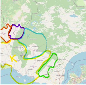
Kara is a multiethnic union of 5 previous independent republics who united in the 20th century. The five main ethnic areas are Kårska (yellow), Thilshull (green), Kirek (purple), Reuntha (blue), and Vezhek (red).
Proposal
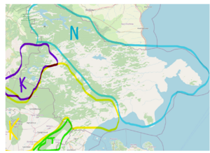
Kara would still have 5 cultures:
- The Vezhek culture would remain as-is (not shown on the proposal map)
- Kårska would remain the primary culture of the country. It would expand throughout the Tebbjet River Valley and some of the coastal plain.
- The Reuntha language and culture would be removed (I haven't really done any work on developing that area or the culture)
- The Kirek culture would remain a sparse group. The area would use runes as writing. It would retain its current area and expand into parts of what is currently Reunthan and into part of the expansion territory.
- Thilshull culture would remain essentially the same.
- A new culture would occupy the majority of the new coastal area and would cover most of the northeast portion of the country. I'll describe the culture in the next section.
| History & culture | |
|---|---|
| A brief description of the intended culture and language |
Current Cultures
- Kårska culture is primarily inspired by Swedish and other Nordic cultures. The language has the same origin and has a lot of similarities to Swedish.
- Kirek culture is also influenced by Swedish and other influences. It's language is close to mutually intelligible with Kårska. The biggest difference is that the language is written in Runic characters rather than Latin/Roman ones.
- Thilshull is an Ingerish-speaking culture with ties to Glaster.
It should be noted that there has been a lot of ethnic and cultural mixing within Kara. Many people can claim ancestry from multiple of these groups, and significant portion (and a majority in the case of Kirek) of these cultures' members live in the southern, Kårska-dominated part of the country.
New Culture
Like the other cultures in Kara, the new, yet-to-be-named culture is heavily influenced by Nordic culture. The language is Germanic (Gaermanic) with some Latin (Latinic) influences. It's particularly influenced by Swedish and Nordic languages. It has a 37-letter alphabet. Most of the characters are Latin, with a few Greek characters. The language has a phonetic orthography, meaning that each letter represents a single sound and that each sound is represented by only one letter.
| letter | technical name | ipa | example in American English |
| §§ | voiceless uvular fricative | ⟨χ⟩ | German "ch" in words like "Bach", etc. |
| Aa | open front unrounded vowel | ⟨a⟩ | "a" in bad |
| Ææ | ⟨aɪ⟩ | "y" in by | |
| Dd | voiced alveolar plosive | ⟨d⟩ | "d" in english |
| Ðð | voiced dental fricative | ⟨ð⟩ | "th" in they |
| Ee | mid central vowel | ⟨ə⟩ | schwa (neutral vowel) |
| Ff | voiceless labiodental fricative | ⟨f⟩ | "f" in far |
| Gg | voiced velar plosive | ⟨ɡ⟩ | "g" in good |
| Hh | voiceless glottal fricative | ⟨h⟩ | "h" in happy |
| Ii | close front unrounded vowel | ⟨i⟩ | "ee" in meet |
| Jj | voiced palatal approximant | ⟨j⟩ | "y" in you |
| Kk | voiceless velar plosive | ⟨k⟩ | "c" in can |
| Ll | voiced alveolar lateral approximant | ⟨l⟩ | "l" in like |
| Mm | voiced bilabial nasal | ⟨m⟩ | "m" in morning |
| Nn | voiced alveolar nasal | ⟨n⟩ | "n" in no |
| Ññ | voiced palatar nasal | ⟨ɲ⟩ | "ñ" |
| Œœ | ⟨oʊ⟩ | "ow" in low | |
| Oo | open back unrounded vowel | ⟨ɑ⟩ | "o" in dot, "au" in aught (cot-caught merger) |
| Öö | close-mid back rounded vowel | ⟨o⟩ | "ó" in camión |
| Øø | ⟨aʊ⟩ | "ou" in loud | |
| Rr | voiced alveolar trill | ⟨r⟩ | rolled "r" |
| Řř | voiced (post)alveolar approximant | ⟨ɹ⟩ | "r" in run |
| Ss | voiceless alveolar silibant fricative | ⟨s⟩ | "s" in so |
| ßß | voiceless palato-alveolar fricative | ⟨ʃ⟩ | "sh" in shut |
| Tt | voiceless alveolar plosive | ⟨t⟩ | "t" in english |
| Uu | close back rounded vowel | ⟨u⟩ | "oo" in goop |
| Vv | voiced labiodental fricative | ⟨v⟩ | "v" in victory |
| Ww | voiced labial-velar approximant | ⟨w⟩ | "w" in water |
| Xx | voiceless palato-alveolar silibant affricate | ⟨t͡ʃ⟩ | "ch" in choose |
| Yy | ⟨eɪ⟩ | "ay" in day | |
| Zz | voiced alveolar silibant fricative | ⟨z⟩ | "z" in zebra |
| Žž | voiced alveolar silibant affricate | ⟨d͡z⟩ | "ds" in ends |
| Ʒʒ | voiced postalveolar fricative | ⟨ʒ⟩ | "zh" |
| Ǯǯ | voiced palato-alveolar silibant affricate | ⟨d͡ʒ⟩ | "j" in jaw |
| Þþ | voiceless dental fricative | ⟨θ⟩ | "th" in think |
| Δδ | glottal plosive | ⟨ʔ⟩ | glottal stop |
| Πη | voiced velar nasal | ⟨ŋ⟩ | "ng" in sing |
You can access recordings of the IPA sounds here.
| Past mapping | |
|---|---|
| To support your request provide links to areas of OGF mapping which showcase your mapping skill. Mapping relevant to the requested theme & geography is especially useful | |
| The {{coord}} template can optionally be used to link to the OGF map - it results in a nice formatted link. Or you can paste in a URL. |
A couple of highlights from the currently-mapped parts of Kara:
Kärrstad, a mid-size city along the marshy shores of Kärrsö (the city's name means "marsh city") with a state-of-the-art light rail system and a large park over an underground state road and the surrounding towns, villages, and farms
Viskestad, a small fishing town (its name translates to "fish town") on a windswept island formed by two volcanoes
Nådensted, a small town in Kara's central mountains
Nykojpeng, a town along the Roving River with several nearby villages
Jacobsborough, a quiet Thilshullian town along the Brand River with lots of farmland
Thilshull, a small city serving as the capital of Thilshull State
Johansberg, a quaint town nestled along the mountains that define the Bjergdal Valley
Vjèlmik, a small village along the border of Vezhek State
Hjeplingåde, a large city at the fork of the Roving and Murra Rivers
Kåra, the capital city of the country (it's in its early stages of development)
| Username & date | |
|---|---|
| Sign and date the application by typing four tildes like this: ~~~~ |
Anonymous21 (talk) 03:09, 5 February 2023 (UTC)
 | Discussion |
|---|---|
| Discussion for clarification & decision |
- Hello Anonymous21, thank you for your detailed proposal. At this point in time I am afraid I have to reject your proposal, as Kåra is not yet sufficiently mapped to allow for a territory expansion. Thank you for your understanding. Cheers, Leowezy (talk) 16:08, 5 February 2023 (UTC)
| Territory application closed | |
|---|---|
| Existing territory not sufficiently mapped yet to grant expansion. Leowezy (talk) 16:08, 5 February 2023 (UTC) | |
| optionally useful information for the user |


