Larcetany

|
Republic of Larcetany República d'Ellarça (Larcetan) |
Loading map... |
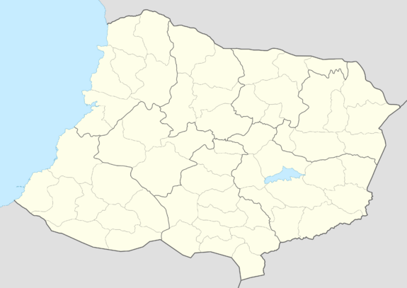
Larcetany (/lar'sɛ'təni/, pronounced: lar-SEH-tuh-nee; Larcetan: Ellarça, pronounced: [ə'ʎarsə], uh-YAR-suh), officially The Republic of Larcetany (Larcetan: República d'Ellarça), is a sovereign state in southwestern Uletha∈⊾. It is bordered by Saiol to the south, Alora to the north, UL04e to the southeast and Lucetia Regalis to the east. The Larcetan shores, west of the country, lie on the Mesembric Sea∈⊾. The capital and largest city of the country is Cirtella, located in the southwest of the country.
Diplomatically, it is a member of the Association of South Ulethan Nations, after joining in 19xx.
Etymology
Both the endonym (Ellarça) and the common exonym for Larcetany have the same origin. During the classical era, before the *romantian* invasion of the lands that are currently Larcetany, geographers described the peoples living between the Braida and the Casquer river mouths as Larcetanii. Eventually, those lands would be called Larcetania, which would become Llarcetania, Ellarcetania, and eventually Ellarça in the native Larcetan.
Geography
History
| History of Larcetany | |
|---|---|
| Kingdom of the Southeast | |
| • Foundation of the county of Cirtella | |
| • Foundation of the county of Mingó | |
| • Breakup with Lustria | |
| Principality of Larcetany | |
| • Castellanese vassal state | |
| • Independence war | 1658-1662 |
| • Foundation of the Larcetan Court | 1813 |
| Republic of Larcetany | 1882- |
| • Socialist revolution | 1927 |
| • Reactionary coup d'état | 1942 |
| • Democratic restoration (Fourth republic) | 1957 |
Pre-"Romantian" Period
xxx
"Romantian" Period
xxx
"Romantian" Kingdom of the Southeast
xxx
Larcetan Counties
xxx
Castellanese vassal period
xxx
Independence War
xxx
Independent Larcetany
Absolutist period
xxx
Larcetan Court: Constitutional monarchy
xxx
Republican period
Republican revolution
xxx
Socialist period
xxx
Military dictatorship
xxx
Fourth republic: Democratic restoration
xxx
Politics and Government
Government buildings
Most government buildings and ministries are in the Eixample district of the capital city, Cirtella.
Ministry of Infrastructures and Transportation
Ministry of the Presidency (Government Palace)
Administrative divisions
 | |
|---|---|
| Administrative divisions of Larcetany | |
| First-level | 8 regions (Larcetan: Vegueries) |
| Second-level | 60 counties (Larcetan: Comarques) |
| Third-level | Municipalities (Larcetan: Municipis) |
There are three main levels of administrative divisions in Larcetany: regions (Vegueries), counties (Comarques) and municipalities (Municipis)
| Region | Capital | Number of counties |
Land area | Population | Population density | ||
|---|---|---|---|---|---|---|---|
| km² | mi² | km² | mi² | ||||
| Altolà i Errates∈⊾ | Votlla | 7 | 5,879 | 2,270 | TBD | TBD | TBD |
| Vall Colomera∈⊾ | Creugisa | 5 | 5,156 | 1,991 | TBD | TBD | TBD |
| les Altes∈⊾ | Vidó | 6 | 4,019 | 1,552 | TBD | TBD | TBD |
| Serres de Llevant∈⊾ | Santa Coloma de Berrià | 7 | 5,821 | 2,248 | TBD | TBD | TBD |
| Baixa Ellarça∈⊾ | Cirtella | 9 | 8,102 | 3,128 | TBD | TBD | TBD |
| Comarques Centrals∈⊾ | Vilafranca de Grifós | 4 | 4,468 | 1,725 | TBD | TBD | TBD |
| Valls de Migjorn∈⊾ | Carmajor | 12 | 7,114 | 2,747 | TBD | TBD | TBD |
| Camp de Mingó∈⊾ | Camingó | 10 | 7,737 | 2,987 | TBD | TBD | TBD |
Diplomacy
Larcetany is a member of the Association of South Ulethan Nations, and the Assembly of Nations.
Diplomatic missions
| Country | Larcetan Embassy | Embassy in Larcetany | Consulates |
|---|---|---|---|
| Anglesbury and Youcestershire | 6-8 Nae Street, Whangiora | Carrer de la Independència, 84 | |
| Granovska avenija, Sarengrad | Carrer de Barnils, 21 | ||
| Via eu Cavall, Carante | Carrer del Consell Ellarçà, 107 | ||
| Carrer de la Memòria | |||
| Avinguda del President Balcells | |||
| Плац Крўлевскі, Dobrzanka | |||
| Maslinavia | Opolovac | ||
| Patra Arṣanta Naoță, Arta | Ronda de Sant Just, 35 | ||
| Wellstar Street, Bako-Huz | Carrer del Comtat, 25 |

