Collab:Federal States/Collaborative States/Alormen
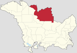
| State of Alormen Alormen | |||
|---|---|---|---|
| |||
| Constituent state of | |||
| |||
| Capital | Alamar | ||
| Largest city | Andreapolis | ||
| Statehood year | 1840 | ||
| Area | |||
| • Total | 411,839 km2 159,012 sq mi | ||
| Population | |||
| • Estimate (2022) | 17,610,000 | ||
| • Census (2020) | 17,554,009 | ||
Introduction
Alormen∈⊾ (AR120-91) is the largest state in the Federal States, with an area roughly 2/3 the size of Texas or slightly smaller than the state of California. It is a guided collaborative inspired by Texas and the south-eastern US.
Coordination
The project is being overseen by ruadh.
Contributors
| Name | County | Notes |
|---|---|---|
| Reserved | Inkana County | A coastal county with longstanding Franquese heritage. Previously mapped by Luziyca |
| Y Knott | Clifton County | Rural, heavily forested |
| Ruadh | Faures County | The county has a resident population of around 10K which more than doubles during the holiday season. Including the Petra Cavalli National National Wildlife Refuge, there are an abundance of natural areas, rivers, wetlands, parks and recreational areas. The local economy is based on tourism, agriculture, hunting and fishing. |
| Ruadh | Rushe County | The population is around 44k, centred in the north along the AL18 historic highway, now the FS-80 highway. The county seat is Coldrey, home to the largest refinery in East Alormen. The county is landlocked and rural in character, dominated by several rivers running south/north towards the Alormen Gulf. The economy relies on the oil and natural gas industry, as well as agriculture, mainly cereals and fruits with some ranching. |
| elindio23 | Nakohe County | |
| Zytik | Klamesta County | |
| Zytik | West-15 | |
| RobertTBS | Cross County | |
| Z11 | Stallion County |
Background Information on Alormen
Alormen has a population of around 17.5 million people, the majority of whom live in or around the 10 big cities.
The capital city is Alamar but the largest urban area is Andreapolis/Mahpe. The states busiest seaport is Port Massehanee.
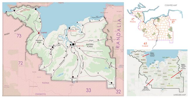
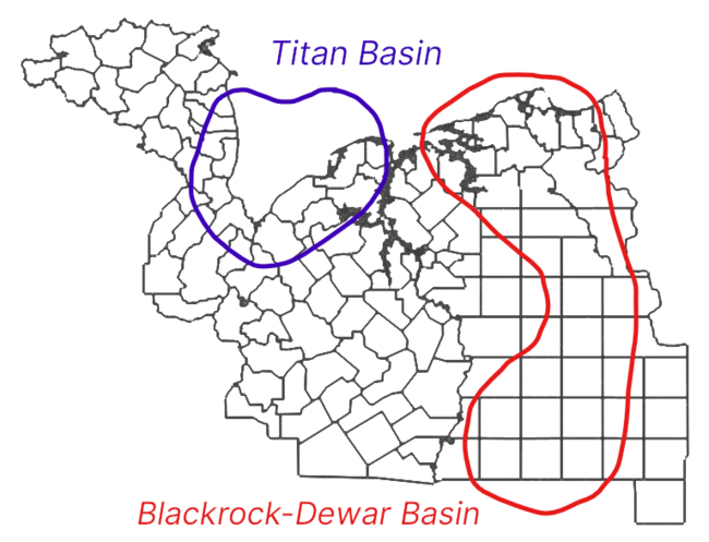
The state is large and subdivided into 129 counties, the majority of which are landlocked, sparsely populated and rural in character. Those within easy commuting distance of large cities will have greater population and wider variety of amenities.
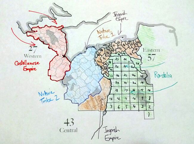
- West - Alamar and some of the oldest settlements lie in the west of the state which was the first area to come under colonial control. Castellanese influence can still be felt in the urban planning and place names of the region. Some typical industries here include mining, forestry and agriculture.
- Central - The central and coastal parts of the state were historically under native control and then became nominally Ingrean for an extended period before the current Alormen state was formed. Native settlements and their place names are more evident here. The Passawanah Valley and the Anawuhak Valley run north/south across the region. Along the coast are a variety of wetlands, swamps, bayous and tidal estuaries, many of which are habitats of international importance. Energy companies own oil and gas extraction operations across the region.
- East - The land that lies east of the 'big river' was annexed to Alormen shortly after the formation of the state and saw a great deal of conflict between native populations, Ingrean settlers/militias and groups associated with Randalia. Unlike the other regions, the counties in the east are very regular squares, having been surveyed and established in more recent times. The eastern landscape is dominated by coastal plains that give way to rolling plains and hill country further south. Important industries include agriculture such as orchards, tourism and ranching.
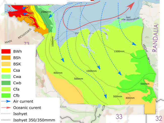
Climate
History
This is an outline of the history of the territory that can be modified and refined over time to fit with wider FSA history.
Pre-History
Pre-contact Alormen was home to more than a dozen large native population groups and dozens more smaller tribes. They are classified by geographical region, each with shared cultural traits and language families. They created the first 'pathways' across the territory and left behind many place names seen on the map today. Some were nomadic and others were settled.
There were three main ethnolinguistic groups, the first inhabited the mountains and valleys west of the 'big river', the second major grouping occupied the eastern plains between the 'big river' and the border with Randalia while the third lived along the coastal region.
Post-Contact Era 1550-1740
1550 - 1680
The Castellanese were the first non-natives to arrive at what is now Puerto Eloisa in the 1550s. In the following decades they moved gradually east, exploring, conquering local tribes, establishing alliances, fortified settlements and churches from which to spread Castellanese influence. It was not a planned colonisation and activity fluctuated depending on the political landscape of the Castellanese royal court and behaviour of the native population. Often they would retain local elites and tribal boundaries, eventually gaining control of the western portion of the modern day state, from Puerto Eloisa to the Nakohe River. The territory was named Santa Annestas after a recently beatified member of the Castellanese royal family.
1680 - 1740
The Ingrean arrived on the northern coast in the 1670s and 80s where they established a small number of successful colonies at various locations including Port Massehanee. Several colonies failed due to a mixture of native resistance, Castellanese interference, poor harvests, disease and lack of support from Ingrea. Like the Castellanese the Ingrean speaking arrivals began exploring inland, moving south along the 'big river' into the interior of the state. The Ingrean colonisation effort was largely undertaken as private enterprise. Through a combination of trade, military actions and politics they established nominal control over portions of the northern coastline and a few strategic locations southwards along the navigable rivers.
During this era the powers in Randalia were moving west and occupying land held by the eastern plains tribes. This left only natives in the land west of the 'big river' in firm control of their historic tribal lands. Many refugees from other tribes were absorbed into this group.
Franquese explorers and colonists also navigated the big river during this period. Many settlers arrived from the older southern colonies and several communities still exist that trace their roots back to these pioneers.
Consolidation 1740-1800
The Castellanese and Ingrean colonies in the region grew in confidence and capability. The Castellese territories, with easy access to the Asperic Ocean, grew more rapidly and became more developed than the colonial efforts in the east of the state.
1800 - 1809
Due to wars overseas and falling revenues from the mines of Santa Annestas, the Castellanese were forced to cede/sell control of their territory to the Ingrean. Due to the mountainous geography and resistance from Castellanese settlers and natives alike the new lands proved expensive to garrison and less profitable than hoped. In an attempt to subdue the remaining native tribes and unite their disparate holdings the Ingrean prosecuted a series of low level 'wars' but after decades of conflict they failed to break native resistance. The conflicts left much of the countryside too ravaged and depopulated to be support agriculture. Randalia controlled nearly all the land east of the 'big river'.
Modern History
1809 - 1840 The Alormen Republic
1840 - 1850 Joined the Union
1850 - 1860 Annexed East Alormen from Randalia.
Demographics
State parks, nature reserves and wildlife sanctuaries
Use a relation to map out state parks, nature reserves and other types of wildlife sanctuary, refuge or management area. Always include the following tags; boundary=protected_area and leisure=nature_reserve. It is also helpful to designate a suitable "protection_title" and "protect_class".
Electricity Generation
Total State production: 286 TWh approx
Sources
- Coal (19.0%)
- Natural Gas (53.5%)
- Hydroelectric (0.3%)
- Wind (17.3%)
- Nuclear (8.6%)
- Biomass (0.3%)
- Solar (0.9%)
- Other (0.1%)
Types of generation
- 1 nuclear 2100mw
- 10 coal/lignite 500-1500mw each
- 32 natural gas 500-2000mw each
- 4 biomass 20-100mw
- 8 hydroelectric 20-150mw
- 100+ wind large/medium scale 150-500mw
- 100+ small scale10-500mw
Economy
There has been oil production in Alormen for over one hundred years and hydrocarbon extraction is an important segment of the state economy. Pipelines, refineries and the wider downstream sector have played a key role in the industrialisation of the state, especially in central and east Alormen.
Highways
National Routes - Interactive Map
There are 9 major Federal States Motorways running through Alormen. Many of these routes also include tertiary three-digit bypass or spur routes to provide additional connections and congestion relief in urban areas.
Loading map...

State Routes
All state routes are referenced AL-xx. In general, even numbers run east/west and odd numbers run north/south.
AL-1x
AL-1x routes are located north/north-east of Andreapolis and north of Dewar.
Get Involved
If you want to get involved please message either of us directly, ruadh or newflanders. There are many projects available that would suit a variety of interests, skill levels and time commitments. These range from large scale natural feature detailing, intermediate county/city level urban and rural planning through to small scale key infrastructure mapping.
The geography, hydrology, population centres and transport network of the state have been roughly mapped out but Alormen is huge and there is a great deal to do! We hope this framework will inspire you and help you to map something unique, set within a fairly coherent bigger picture.
- Most rural counties are now available to individual mappers, on request. The counties allow you free rein, within some general population and natural features guidelines. Counties operate like small states with a local government structure, services provision, police and fire, industry and commerce, even their own seals and symbols. They have all the benefits of a full size country but are small enough to be achievable projects in the shorter term.
- Broader projects such as road and rail development, hydrology and other natural features. There are mappers out there in the community with a great deal of knowledge about these big infrastructure pieces and we'd love to hear from you!
| Collaborative Projects | States: Territories: Protectorates: |
|---|---|
| Natural Environment | National Parks • Natural features |
| Commerce | Franchises • Industries |
| Infrastructure | Government • Military • Transportation |
| Worldbuilding | History • Important persons • International relations • Non-governmental organizations • Sports • State profiles |
| Project Communication | Main project page • Discord (request access) • Federal States Forum (archive) • Newcomers Guide • Archives |

